
HVO helicopter overflight of Kīlauea Volcano’s summit
By Kīlauea

Detailed Description
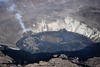
During an HVO helicopter overflight of Kīlauea Volcano’s summit this morning (December 30), geologists collected photos and thermal imagery to document eruptive changes and to make maps of the lava lake within Halema‘uma‘u crater. This aerial photo, taken at approximately 10:00 a.m. HST, shows the lava lake that is slowly rising within Halema‘uma‘u crater. The west vent remains active and continues to emit a small plume. SO2 emission rates remain elevated. USGS photo taken by L. DeSmither.
Sources/Usage
Public Domain.