
Indiana and Landsat


See Indiana from Space
Use the links below to explore more Landsat resources highlighting Indiana.
Detailed Description
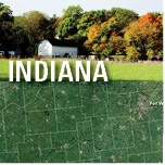
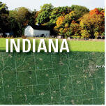
Natural resources have always been a strength for Indiana. Once largely covered by forest, the State now includes a mix of forest, farmland, wetlands, and small lakes. In fact, farms and forested areas make up more than 80 percent of the land. The Ohio River forms the southern border, and the south shore of Lake Michigan contrasts with urban development in the northwestern corner. Indiana Dunes National and State Parks reside just east of the Chicago metropolitan area.
Agriculture adds more than $30 billion to the economy in Indiana, which placed eighth in the country for agricultural exports at $4.6 billion in 2017. Indiana ranks in the top five States nationally for the production of corn and soybeans. The “Hoosier State” also grows sizable crops of popcorn, spearmint, peppermint, pumpkins, tomatoes, and watermelon. Additionally, hogs, cattle, dairy, and poultry contribute to the agricultural economy. Other industries important to Indiana include manufacturing, medicine, energy, and mining. Mineral sources vary from coal, building stone, and gypsum to sand, gravel, and shale.
Landsat can help monitor the condition of natural resources and the effects of extreme weather events.
Visit Landsat Benefits, State By State to learn more about how Landsat brings science to your state.
Sources/Usage
Public Domain.