
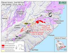
Kīlauea Lower East Rift Zone Fissures and Flows, May 18 at 1pm HST

Detailed Description
This map shows the eruption fissures and flows at Kilauea volcano's Lower East Rift Zone at 1 p.m. HST, May 18, 2018. Shaded purple areas indicate lava flows erupted in 1840, 1955, 1960, and 2014-2015.
Sources/Usage
Public Domain.