
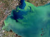
Lake Erie algal bloom
By Earth Resources Observation and Science (EROS) Center
September 2017 (approx.)

Detailed Description
Landsat 8 captured this image of Lake Erie during a harmful algal bloom event on September 26, 2017.
Sources/Usage
Public Domain.
Related

CMHRP Links with Other Mission Areas
Strategy: Coordinate with other USGS Mission Areas and Programs to understand and predict the complex interactions within coastal and marine systems and the environmental and human consequences of natural and human processes. There are several emerging and established opportunities for collaborative prioritization, planning, and program development with other Mission Areas.

Harmful Algal Blooms (HABs)
The USGS collaborates with local, state, federal, tribal, university, and industry partners to conduct the science necessary to understand the causes and effects of toxic HABs and inform water management and public health decisions. USGS is characterizing the life cycle of HABs, their asociated toxins, and the genes responsible for cyanotoxin production. This work is enhancing the ability of Great...

How is the Landsat 8 and Landsat 9 Coastal/Aerosol Band 1 used? How is the Landsat 8 and Landsat 9 Coastal/Aerosol Band 1 used?
The Operational Land Imager Band 1 ( 0.433-0.453 µm) on Landsat 8 and Landsat 9 is useful for imaging shallow water and tracking fine atmospheric particles like dust and smoke. Band 1 reflects blues and violets, where light is scattered by dust, smoke, and water particles in the air. Collecting data with enough sensitivity at this spectrum is difficult. Since water absorbs and scatters light...
Related
CMHRP Links with Other Mission Areas
Strategy: Coordinate with other USGS Mission Areas and Programs to understand and predict the complex interactions within coastal and marine systems and the environmental and human consequences of natural and human processes. There are several emerging and established opportunities for collaborative prioritization, planning, and program development with other Mission Areas.
Harmful Algal Blooms (HABs)
The USGS collaborates with local, state, federal, tribal, university, and industry partners to conduct the science necessary to understand the causes and effects of toxic HABs and inform water management and public health decisions. USGS is characterizing the life cycle of HABs, their asociated toxins, and the genes responsible for cyanotoxin production. This work is enhancing the ability of Great...
How is the Landsat 8 and Landsat 9 Coastal/Aerosol Band 1 used? How is the Landsat 8 and Landsat 9 Coastal/Aerosol Band 1 used?
The Operational Land Imager Band 1 ( 0.433-0.453 µm) on Landsat 8 and Landsat 9 is useful for imaging shallow water and tracking fine atmospheric particles like dust and smoke. Band 1 reflects blues and violets, where light is scattered by dust, smoke, and water particles in the air. Collecting data with enough sensitivity at this spectrum is difficult. Since water absorbs and scatters light...