
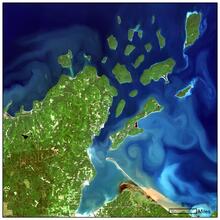
Landsat 8 image of the Apostle Islands in Lake Superior

Detailed Description
Citation: Citation_Information: Originator: U.S. Geological Survey (USGS) Earth Resources Observation and Science (EROS) Center Publication_Date: 2013 Title: LANDSAT 8 OLI/TIRS Collection 1 - Path: 26 Row: 27 for Scene: LC08_L1TP_026027_20180907_20180912_01_T1 Geospatial_Data_Presentation_Form: Remote-Sensing Image Publication_Information: Publication_Place: Sioux Falls, South Dakota, USA Publisher: U.S. Geological Survey (USGS) Earth Resources Observation and Science (EROS) Center Online_Linkage: https://lta.cr.usgs.gov/L8 Description: Abstract: The USGS Earth Resources Observation and Science (EROS) Center archive holds data collected by the Landsat suite of satellites, beginning with Landsat 1 in 1972. Landsat 8, launched February 11, 2013, is the latest Landsat sensor. Purpose: The Landsat archive provides a rich collection of information about the Earth's land surface. Major characteristics of changes to the surface of the planet can be detected, measured, and analyzed using Landsat data. The information obtainable from the historical and current Landsat data play a key role in studying surface changes through time. Supplemental_Information: Landsat represents the world's longest continuously acquired collection of space-based moderate-resolution land remote sensing data. As a joint initiative between the U.S. Geological Survey (USGS) and the National Aeronautical Space Administration (NASA), the Landsat Project and the data it collects support government, commercial, industrial, civilian, military, and educational communities throughout the United States and world. Landsat 8 Operational Land Imager (OLI)/Thermal Infrared Sensor (TIRS) Collection 1 provides a quality-controlled selection of radiometrically calibrated and consistently geolocated data; particular geodetic accuracy and error tolerances are specified to align pixels for time series analysis through the full Landsat record.
Sources/Usage
Public Domain.