
Landsat 8 View of California Drought

Detailed Description
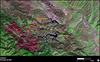
In this December 29, 2016, Landsat 8 view of California’s Lake San Antonio and Lake Nacimiento, the decade-long drought’s effects can be seen in the low water level. Credit: USGS/NASA Landsat program.