
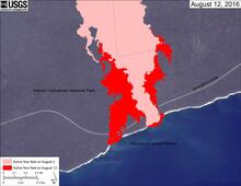
Map of coastal flow field

Detailed Description
This map shows recent changes to Kīlauea's East Rift Zone lava flow field at the coast. The area of the active flow field as of August 2 is shown in pink, while widening and advancement of the active flow as mapped on August 12 is shown in red. The base is a Digital Globe image from January 2016.