
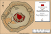
Map of Halema‘uma‘u collapse after 1960 Kapoho. Central pit is most...
By Volcano Hazards Program
1905 (approx.)

Detailed Description
Map of Halema‘uma‘u Crater collapse after 1960 Kapoho. Central pit is most evident. Second pit is in southwest part of the subsidence saucer, and March 11 pit is outside the saucer in northeast corner.