
Map of Kīlauea showing the south-SE motion, as recorded by continuo...
By Hawaiian Volcano Observatory
2010 (approx.)

Detailed Description
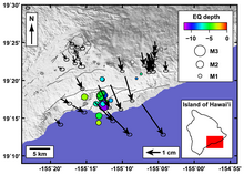
Map of Kīlauea Volcano showing the south-southeast motion, as recorded by continuous GPS sites (arrows), and earthquake epicenter between February 1-3, 2010.
Sources/Usage
Public Domain.