
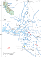
Map of the Sacramento/San Joaquin Delta

Detailed Description
Map of the Sacramento/San Joaquin Delta.
Sources/Usage
Public Domain.
Related

Understanding Juvenile Salmon Entrainment and Survival in the South Sacramento/San Joaquin Delta Through the Use of Acoustic Telemetry and Hydrodynamic Measurements
This study will use the release-recapture information derived from the 2012 receiver array to populate a mark-recapture model based on a Cormack-Jolly-Seber model in combination with a route-specific survival model of Skalski et al. (2002) to derive maximum likelihood estimates and standard errors of reach specific survival and entrainment rates at important junctions, similar to what was used in...
Related
Understanding Juvenile Salmon Entrainment and Survival in the South Sacramento/San Joaquin Delta Through the Use of Acoustic Telemetry and Hydrodynamic Measurements
This study will use the release-recapture information derived from the 2012 receiver array to populate a mark-recapture model based on a Cormack-Jolly-Seber model in combination with a route-specific survival model of Skalski et al. (2002) to derive maximum likelihood estimates and standard errors of reach specific survival and entrainment rates at important junctions, similar to what was used in...