
Map of Seaside, Oregon, that shows statistical results

Detailed Description
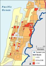
Map of Seaside, Oregon, that shows statistical results of a social vulnerability index, which identifies relative areas of heightened demographic sensitivity to a tsunami (blue line) associated with a Cascadia subduction zone earthquake
Sources/Usage
Public Domain.
Related

Tsunamis
The 2004 Indian Ocean, 2010 Chilean, and 2011 Tohoku disasters have shown how tsunamis are significant threats to coastal communities. To help U.S. coastal communities prepare for future tsunamis, the Hazards Vulnerability Team completed projects related to population exposure and sensitivity, pedestrian evacuation modeling, and vertical-evacuation decision support. A recent article of ours in the...
Related
Tsunamis
The 2004 Indian Ocean, 2010 Chilean, and 2011 Tohoku disasters have shown how tsunamis are significant threats to coastal communities. To help U.S. coastal communities prepare for future tsunamis, the Hazards Vulnerability Team completed projects related to population exposure and sensitivity, pedestrian evacuation modeling, and vertical-evacuation decision support. A recent article of ours in the...