
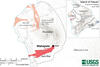
Map showing the location of the Wahapele vent and lava flow on Hualālai volcano

Detailed Description
This map shows the location of the Wahapele vent (star) and lava flow (red) on Hualālai volcano. The approximate boundary between Hualālai and Mauna Loa is indicted by a dashed line. The lava flow extends 2 kilometers (1.25 miles) farther into the ocean. The inset map shows the entire Island of Hawaiʻi, with approximate volcano boundaries indicated with a thick grey line. All eruptions since 1800 are shaded grey, with the exceptions of Kīlauea’s 2018 lower East Rift Zone eruption (blue) and Hualālai's recent eruptions (1800-1801 and earlier, in peach). Geology is from Sherrod and others (2021).
Sources/Usage
Public Domain.