
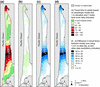
Maps showing pedestrian travel times across the Long Beach Peninsula

Detailed Description
Maps showing pedestrian travel times across the Long Beach Peninsula, Washington, based on an anisotropic modeling approach and various data sets. a Shows results of the anisotropic using 1-m elevation data and 1-m land-cover data. b–d Show the difference at each grid cell between a and b 1-m elevation and 30-m NLCD data, c 10-m elevation and 1-m land-cover data, and d 10-m elevation and 30-m NLCD data
Sources/Usage
Public Domain.