
Measuring topographic change with 4D photogrammetry
By Pacific Coastal and Marine Science Center
May 2017 (approx.)

Detailed Description
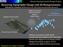
Provisional data subject to revision. From the USGS Remote Sensing Coastal Change Project, illustration describes how the USGS measures topographic change with 4D photogrammetry utilizing the techniques of Warrick et al., 2017. A digital terrain model of a coastal cliff is shown with its ground control points. The figure shows the locations in space where aerial photographs of the cliff were taken from different sources: California Coastal Records Project (CCRP) photos (2002-2015), and USGS photos (March & May 2017).
- Oblique aerial photos (CCRP, USGS)
- Ground control provided by 2016 USGS lidar
- Results show Digital Terrain Models (DTMs)
- Change uncertainty is approximately 0.75 m
- Positions have high precision and accuracy
Sources/Usage
Public Domain.