
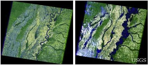
Mississippi River near Tennessee, Kentucky, Missouri, Arkansas
Detailed Description
The 2006 image (left) show the river in a more normal state, while the 2011 image (right) shows the massive flooding. The dark blue tones represent water or flooded areas, the light green is cleared fields, and light tones are clouds.
Recent Landsat satellite data captured by the U.S. Geological Survey and NASA on May 10 show the major flooding of the Mississippi River along the state borders of Tennessee, Kentucky, Missouri, and Arkansas as seen from 438 miles above the Earth.
Sources/Usage
Public Domain.