
National Shoreline Change Data

Detailed Description
The U.S. Geological Survey (USGS) maintains shoreline positions for the United States coasts from both older sources, such as aerial photos or topographic surveys, as well as contemporary sources like lidar elevation point clouds and digital elevation models (DEMs). These shorelines are compiled and analyzed in the Digital Shoreline Analysis System (DSAS) software to compute rates of change. It is important to keep, and make available, records of historical shoreline positions to allow monitoring of change over time, and to identify areas most susceptible to erosion or accretion. These data can help coastal managers identify areas of the coast that are most likely to experience significant change over time.
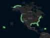
Highlighted areas represent locations of USGS shoreline change data products.
Sources/Usage
Public Domain.