
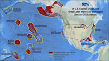
Percentage of U.S. coastal, ocean, and Great Lakes waters that are unmapped

Detailed Description
Percent of U.S. waters that remain unmapped as of January 2022: U.S. total – 52% of 3,590,500 square nautical miles (snm).
NOMEC is the national effort led by the Ocean Policy Committee through the Ocean Science and Technology Subcommittee’s National Strategy for Ocean Mapping, Exploration, and Characterization (NOMEC) Council. The Council was formed in 2020 to coordinate agency policy and actions needed to advance ocean mapping, exploration, and characterization, and to support collaboration with non-governmental partners and stakeholders as well as government-to-government collaborations with Tribal Nations. The Council works to develop and implement multi-disciplinary, collaborative, and coordinated approaches to mapping, exploring, and characterizing the United States EEZ. The Council reports to the Ocean Science and Technology Subcommittee, which provides support and guidance for the Council’s work as appropriate. The Ocean Policy Committee also provides strategic direction and facilitates interagency resolution of policy issues as appropriate.
Read the NOMEC Strategy.
Sources/Usage
Public Domain.