
Pre-Oil Reconnaissance Flight

Detailed Description
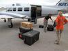
USGS geologists Karen Morgan and Ginger Tiling-Range load imaging gear for a pre-oil reconnaissance flight. USGS captured more than 350 miles of Florida's coastline, from Cedar Key to Flamingo, with over 9,800 aerial photographs. The photographs document conditions along Florida's coastline in advance of the arrival of oil from the Deepwater Horizon incident.
Sources/Usage
Public Domain.