

Geophysical survey equipment hoop on ground with people learning from SkyTEM member. In January 2021 a helicopter carried an airborne electromagnetic induction sensor over parts of northeastern Wisconsin as part of a USGS study to map the aquifers in the region.
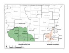
Proposed survey area for 2022 Wisconsin airborne electromagnetic (AEM) survey

Detailed Description
Proposed survey area for 2022 Wisconsin airborne electromagnetic (AEM) survey.
Sources/Usage
Public Domain.
Related Content
Below is science associated with this image.
Airborne Electromagnetic (AEM) Survey 2022
The U.S. Geological Survey (USGS) is conducting an Airborne Electromagnetic (AEM) Survey project in Southwestern and Southeastern Wisconsin. The survey is in partnership with Wisconsin Geological and Natural History Survey (WGNHS), Natural Resources Conservation Service (NRCS) and Wisconsin Department of Agriculture, Trade and Consumer Protection (DATCP).
Below is media associated with this image.

Electromagnetic geophysical survey hoop on ground
Geophysical survey equipment hoop on ground with people learning from SkyTEM member. In January 2021 a helicopter carried an airborne electromagnetic induction sensor over parts of northeastern Wisconsin as part of a USGS study to map the aquifers in the region.

Geophysical equipment loop with sensor for airborne electromagnetic survey January 2021
Geophysical equipment loop with sensor from SKYTEM. In January 2021 a helicopter carried an airborne electromagnetic induction sensor over parts of northeastern Wisconsin as part of a USGS study to map the aquifers in the region.
Geophysical equipment loop with sensor from SKYTEM. In January 2021 a helicopter carried an airborne electromagnetic induction sensor over parts of northeastern Wisconsin as part of a USGS study to map the aquifers in the region.

Helicopter with geophysical survey equipment loop deployed below for airborne electromagnetic survey, Northeastern Wisconsin, January 2021
linkPhoto of helicopter with geophysical equipment loop deployed below it via slingload. Technician for scale. In January 2021 a helicopter carried an airborne electromagnetic induction sensor over parts of northeastern Wisconsin as part of a USGS study to map the aquifers in the region.

Helicopter towing hoop for airborne electromagnetic survey northeastern Wisconsin, January 2021
linkPhoto of helicopter with geophysical equipment loop deployed below it via slingload. In January 2021 a helicopter carried an airborne electromagnetic induction sensor over parts of northeastern Wisconsin as part of a USGS study to map the aquifers in the region.

Explanation of electromagnetic geophysical survey equipment
A SkyTEM team member explains technology behind geophysical equipment loop to USGS employees. In January 2021 a helicopter carried an airborne electromagnetic induction sensor over parts of northeastern Wisconsin as part of a USGS study to map the aquifers in the region.
A SkyTEM team member explains technology behind geophysical equipment loop to USGS employees. In January 2021 a helicopter carried an airborne electromagnetic induction sensor over parts of northeastern Wisconsin as part of a USGS study to map the aquifers in the region.

Electromagnetic geophysical survey hoop
Geophysical equipment survey hoop resting on ground in between flights. In January 2021 a helicopter carried an airborne electromagnetic induction sensor over parts of northeastern Wisconsin as part of a USGS study to map the aquifers in the region.
Geophysical equipment survey hoop resting on ground in between flights. In January 2021 a helicopter carried an airborne electromagnetic induction sensor over parts of northeastern Wisconsin as part of a USGS study to map the aquifers in the region.
Related Content
Below is science associated with this image.
Airborne Electromagnetic (AEM) Survey 2022
The U.S. Geological Survey (USGS) is conducting an Airborne Electromagnetic (AEM) Survey project in Southwestern and Southeastern Wisconsin. The survey is in partnership with Wisconsin Geological and Natural History Survey (WGNHS), Natural Resources Conservation Service (NRCS) and Wisconsin Department of Agriculture, Trade and Consumer Protection (DATCP).
Below is media associated with this image.
Electromagnetic geophysical survey hoop on ground
Geophysical survey equipment hoop on ground with people learning from SkyTEM member. In January 2021 a helicopter carried an airborne electromagnetic induction sensor over parts of northeastern Wisconsin as part of a USGS study to map the aquifers in the region.
Geophysical survey equipment hoop on ground with people learning from SkyTEM member. In January 2021 a helicopter carried an airborne electromagnetic induction sensor over parts of northeastern Wisconsin as part of a USGS study to map the aquifers in the region.
Geophysical equipment loop with sensor for airborne electromagnetic survey January 2021
Geophysical equipment loop with sensor from SKYTEM. In January 2021 a helicopter carried an airborne electromagnetic induction sensor over parts of northeastern Wisconsin as part of a USGS study to map the aquifers in the region.
Geophysical equipment loop with sensor from SKYTEM. In January 2021 a helicopter carried an airborne electromagnetic induction sensor over parts of northeastern Wisconsin as part of a USGS study to map the aquifers in the region.
Helicopter with geophysical survey equipment loop deployed below for airborne electromagnetic survey, Northeastern Wisconsin, January 2021
linkPhoto of helicopter with geophysical equipment loop deployed below it via slingload. Technician for scale. In January 2021 a helicopter carried an airborne electromagnetic induction sensor over parts of northeastern Wisconsin as part of a USGS study to map the aquifers in the region.
Helicopter towing hoop for airborne electromagnetic survey northeastern Wisconsin, January 2021
linkPhoto of helicopter with geophysical equipment loop deployed below it via slingload. In January 2021 a helicopter carried an airborne electromagnetic induction sensor over parts of northeastern Wisconsin as part of a USGS study to map the aquifers in the region.
Explanation of electromagnetic geophysical survey equipment
A SkyTEM team member explains technology behind geophysical equipment loop to USGS employees. In January 2021 a helicopter carried an airborne electromagnetic induction sensor over parts of northeastern Wisconsin as part of a USGS study to map the aquifers in the region.
A SkyTEM team member explains technology behind geophysical equipment loop to USGS employees. In January 2021 a helicopter carried an airborne electromagnetic induction sensor over parts of northeastern Wisconsin as part of a USGS study to map the aquifers in the region.
Electromagnetic geophysical survey hoop
Geophysical equipment survey hoop resting on ground in between flights. In January 2021 a helicopter carried an airborne electromagnetic induction sensor over parts of northeastern Wisconsin as part of a USGS study to map the aquifers in the region.
Geophysical equipment survey hoop resting on ground in between flights. In January 2021 a helicopter carried an airborne electromagnetic induction sensor over parts of northeastern Wisconsin as part of a USGS study to map the aquifers in the region.