
ROV dives off CA and OR and sediment core images

Detailed Description
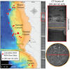
The figure shows the location of remotely operated vehicle (ROV) Doc Ricketts dives conducted in September 2020, plus three images of the CT scan data from one of the collected cores. The ROV is operated by Monterey Bay Aquarium Research Institute (MBARI) from the research vessel (R/V) Western Flyer. The USGS Pacific Coastal and Marine Science Center in Santa Cruz regularly collaborates with MBARI, and most recently the USGS and MBARI efforts center around the study of the Cascadian Margin, a subduction zone off CA, OR, and WA.
The figure includes a photograph of a vertical slice through the upper 80 cm of the core "DR1281 VC-870," with a zoomed in section to the right, outlined in red. Lighter colors indicate sandy sediment and suggest horizons associated with 4 turbidites. In the lower right is a perpendicular slice through a horizon (its location is marked as an orange line through the zoomed-in cross-section) showing coarse grains that are characteristic of turbidites. Previously published work identified a sand layer in a core at this same site and subbottom depth, which was determined to be associated with the January 1700 Cascadia mega-earthquake and subsequent tsunami.
Sources/Usage
Public Domain.

