
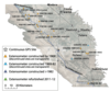
San Joaquin Valley Land Subsidence Monitoring Network (1980s)
By Land Subsidence in California
2015 (approx.)

Detailed Description
History of the San Joaquin Valley Land Subsidence Monitoring Network
By the 1980s, monitoring activities in the San Joaquin Valley were greatly reduced. While 3 new extensometers were constructed, 8 were discontinued, leaving 26 extensometers operating at 18 sites. The decade also brought with it reduced spirit-leveling networks and a decrease in the frequency of measurements.
Sources/Usage
Public Domain.
Related

Land Subsidence in the San Joaquin Valley
The San Joaquin Valley is one of the most productive agricultural regions in the nation. Beginning around the 1920's, farmers relied upon groundwater for water supply. Over time, overpumping caused groundwater-level declines and associated aquifer-system compaction and land subsidence that resulted in permanent aquifer-system storage loss.
Related
Land Subsidence in the San Joaquin Valley
The San Joaquin Valley is one of the most productive agricultural regions in the nation. Beginning around the 1920's, farmers relied upon groundwater for water supply. Over time, overpumping caused groundwater-level declines and associated aquifer-system compaction and land subsidence that resulted in permanent aquifer-system storage loss.