Satellite Imagery of Chilean Wildfires

Detailed Description
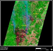
On January 24, 2017, Landsat 8 took this view of wildfire damage in Chile. Credit: USGS/NASA Landsat Program.

Official websites use .gov
A .gov website belongs to an official government organization in the United States.
Secure .gov websites use HTTPS
A lock () or https:// means you’ve safely connected to the .gov website. Share sensitive information only on official, secure websites.
On January 24, 2017, Landsat 8 took this view of wildfire damage in Chile. Credit: USGS/NASA Landsat Program.