
Screenshot of Our Coast, Our Future
By Pacific Coastal and Marine Science Center
2018 (approx.)

Detailed Description
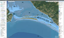
Screenshot of Our Coast, Our Future (OCOF) interactive map view of Stinson Beach, California, showing extent of flooding predicted if subjected to a sea-level rise of 100 centimeters (about 40 inches) and elevated water levels caused by a 100-year storm.
Sources/Usage
Public Domain.
Related Content

Coastal Storm Modeling System (CoSMoS)
The Coastal Storm Modeling System (CoSMoS) makes detailed predictions of storm-induced coastal flooding, erosion, and cliff failures over large geographic scales. CoSMoS was developed for hindcast studies, operational applications and future climate scenarios to provide emergency responders and coastal planners with critical storm-hazards information that can be used to increase public safety...
Related Content
Coastal Storm Modeling System (CoSMoS)
The Coastal Storm Modeling System (CoSMoS) makes detailed predictions of storm-induced coastal flooding, erosion, and cliff failures over large geographic scales. CoSMoS was developed for hindcast studies, operational applications and future climate scenarios to provide emergency responders and coastal planners with critical storm-hazards information that can be used to increase public safety...