
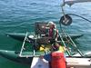
Seismic sled used for sub-bottom surveying
By Coastal and Marine Hazards and Resources Program
September 2019 (approx.)

Detailed Description
USGS scientist Chelsea Stalk stands on a floating sled that enables sub‐bottom surveying in shallow water, nearshore, and shore‐face environments. The sled is equipped with an EdgeTech SB‐512i CHIRP system and single‐beam sonar. This equipment is used to collect seismic sub‐bottom profiles and single‐beam bathymetry. Cedar Island, Virginia has undergone unprecedented erosion and land loss in the last decades. This study was to provide comprehensive baseline data for the nearshore environment for potential future monitoring.
Sources/Usage
Public Domain.