
Seismograms showing Yellowstone M4.8 earthquake on March 30, 2014

Detailed Description
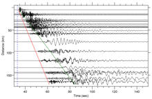
Record section showing horizontal component seismograms from stations in the Yellowstone region from the M4.8 earthquake that occurred near Norris Geyser Basin on March 30, 2014. The vertical blue dashed line represents the origin time of the earthquake at 12:34:39.16 UTC. The red line represents the P-wave arrival with a velocity of ~5.7 km/s. The green line represents the S-wave arrival with a velocity of ~3.2 km/s.
Sources/Usage
Public Domain.