
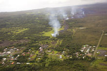
Smoke rises from burning vegetation along edges of lava flow advanc...

Detailed Description
The June 27th lava flow, named for the date in 2014 that the flow started, threatened to inundate different parts of Pāhoa and cross Highway 130 between September 2014 and March 2015. The leading tip of the flow is about 18 km (11 mi) in a straight line distance from the vent located on the flank of Pu‘u ‘Ō‘ō. The flow traveled downslope about 500 m (547 yds) before stalling three days later on October 30, nearly reaching Pāhoa Village Road (bottom of photo).