
Street map of Santa Cruz

Detailed Description
From the San Francisco Bay Area
Take your favorite highway to Hwy 17 South to Hwy 1
At the Hwys 17+1 merge, keep right
Follow signs to “Hwy 1 North, Half Moon Bay, UC Santa Cruz”
Stay on Hwy 1 North (keep in right-most lanes)
Hwy 1 is also named Mission Street — Follow Mission for about 2 miles
At the Western Drive stop light, turn left onto Western Drive
The building right in front of you is the
USGS Pacific Coastal and Marine Science Center
2885 Mission Street
From the south coast or from Hwy 17
Take Hwy 1 North to west Santa Cruz
At the Western Drive stop light, turn left onto Western
The building right in front of you is the
USGS Pacific Coastal and Marine Science Center
2885 Mission Street
From the north coast
Take Hwy 1 South to west Santa Cruz
At the Western Drive stop light, turn right onto Western
The building right in front of you is the
USGS Pacific Coastal and Marine Science Center
2885 Mission Street
Parking
Gated parking lot will be open
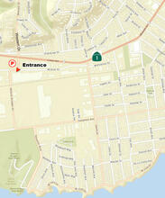
Located on the northwest corner of Western Drive and Mission Street
Limited street parking may be available along Mission Street and along Natural Bridges Drive
Entrance to PCMSC is at 2885 Mission Street
Sources/Usage
Public Domain.
