
sUAS Lidar Training

Detailed Description
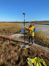
Jen Cramer (USGS Woods Hole Coastal and Marine Science Center) surveys a ground control target using a global navigation satellite system (GNSS) rover at Great Sippewissett Marsh in Falmouth, Massachusetts as part of a multiday small UAS lidar training. These targets will be used to calibrate and validate the geolocation of UAS-derived remote sensing data products.
Sources/Usage
Public Domain.