
Typhoon generates disperse ash cloud, Mount Pinatubo, Philippines

Detailed Description
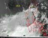
Satellite image of Mount Pinatubo eruption cloud about 2.25 hours after the onset of the climactic phase of the eruption, June 15, 1991. The yellow 'x' marks the volcano. The enormous round shape of the eruption cloud resulted from the pass of tropical storm Yunya across the Philippines about 75 km northeast of Pinatubo during the eruption. Typhoon Yunya made landfall at 0800 June 15 then decreased in intensity to a tropical storm.
Owing at least in part to the atypical lower- and mid-level wind regime spawned by the passing storm, ash and larger particles were widely distributed in all directions immediately around the erupting volcano. Most of the ash was blown to the west southwest over a broad area across the South China Sea; ash dusted parts of Indochina, more than 1,200 km away. (Wolfe and Hoblitt, 1997; online report at http://pubs.usgs.gov/pinatubo/oswalt/index.html).