
Upper Barataria project.png
By Wetland and Aquatic Research Center
August 2023 (approx.)
Detailed Description
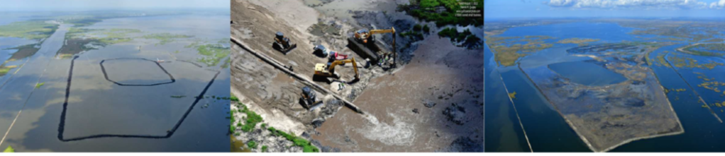
The left image is an aerial view of the Upper Barataria project area before restoration, when it was still submerged. Restoration included the replenishment of sediment dredged from the Mississippi River. The middle and right images show the progress of marsh creation as the vegetation begun to rapidly fill in (Image credit: Patrick M. Quigley, www.gulfcoastairphoto.com).
Sources/Usage
Public Domain.
Photos are courtesy Patrick M. Quigley, www.gulfcoastairphoto.com. Learn more about the Upper Barataria Marsh Creation Project.
Images accessed from https://www.fisheries.noaa.gov/gallery/aerial-photos-upper-barataria-marsh-creation-project
Related

Monitoring and Adaptive Management Plan for Deepwater Horizon Natural Resource Damage Assessment (NRDA) Project: Large-scale Marsh Creation – Upper Barataria Component
USGS will provide support to the Large-scale Marsh Creation – Upper Barataria Component Project by monitoring change in the area of land and water, and recovery of vegetation and elevation over time.
Related
Monitoring and Adaptive Management Plan for Deepwater Horizon Natural Resource Damage Assessment (NRDA) Project: Large-scale Marsh Creation – Upper Barataria Component
USGS will provide support to the Large-scale Marsh Creation – Upper Barataria Component Project by monitoring change in the area of land and water, and recovery of vegetation and elevation over time.