
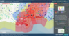
USGS National Water Dashboard Example - Hurricane Watch

Detailed Description
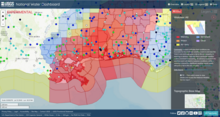
In addition to current conditions provided by USGS observation stations, the NWD allows you to connect with valuable forecast information from the National Weather Service. The red shaded areas display current hurricane watches, while the orange areas are warnings. Find and click on a blue circle. Doing so will provide the latest information about a streamgage site that is above normal flow status. If flooding is above NWS flood stage, the circle will have a magenta halo around it (no sites are experiencing NWS flood stage on the shown map).
Sources/Usage
Public Domain.