
USGS NUSO researchers take a moment to enjoy the scenery during a UAS mission in Colorado

Detailed Description
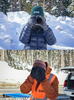
USGS NUSO researchers Victoria Scholl and Mark Bauer take a moment to enjoy the scenery during a UAS data collection for the snow water equivalent (SWE) project at the Berthoud Pass Colorado study site.
NUSO scientists teamed with the USGS Water Resources Mission Area in a multi-year data collection effort to help develop and verify a process for generating snow depth measurements from UAS-collected LiDAR data from 2020 to 2022. This ability to calculate centimeter-level snow depth measurements from remotely sensed data also contributes to the USGS Next Generation Water Observing System (NGWOS) goal of remotely sensed mapping of snow conditions to better forecast snowmelt runoff in Colorado watersheds.
Sources/Usage
Public Domain.