
USGS Produced Coastal Change Forecasts for Hurricane Hanna

Detailed Description
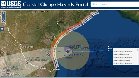
Hurricane Hanna caused high waves and storm surge along the beaches of South Texas and made landfall at Padre Island, Texas at approximately 5pm CDT on July 25, 2020. Prior to landfall, the USGS forecasted that 47% of the coast from Galveston to the Texas-Mexico border was very likely to experience beach and dune erosion. In addition, 2% of dunes were forecast to be very likely to be overwashed by storm waves. None of the dunes were forecast to be inundated.
Sources/Usage
Public Domain.