
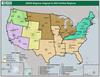
USGS Regional Map

Detailed Description
A map of the USGS Regions that are aligned to the DOI Unified Regions (as of August 2019).
The maps shows USGS Region names:
- Northeast
- Southeast
- Midcontintent
- Rocky Mountain
- Southwest
- Northwest-Pacific Islands
- Alaska
Sources/Usage
Public Domain.