
USGS Streamgage Flooded by Souris River

Detailed Description
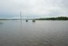
The USGS Souris River at Foxholm, N.D. streamgage (center of photo) is half inundated by water about 30 miles northwest of Minot. This water channel, normally only about 30 feet wide, runs through a wildlife preserve.
As the Souris River flooded during the early summer of 2011, it overcame levees in the city of Minot, N.D., causing about 11,000 people to evacuate their homes. The record-breaking flood crested on July 25 at over 26,000 cubic feet per second (cfs) and 24 feet - nearly 13 feet over flood stage - according to U.S. Geological Survey streamgages in the area.
"An above normal winter snowpack in addition to much above normal precipitation in May and June led to the record flooding along the Souris River," said Steve Robinson of the USGS North Dakota Water Science Center.
The USGS collects data from more than 100 streamgages in North Dakota, most of which provide real-time data that is transmitted every hour. For the latest and most accurate streamflow data for the Souris River Basin in the U.S. and Canada, visit the real-time streamflow web page.
Sources/Usage
Public Domain.