
Well pads in the Colorado Plateau

Detailed Description
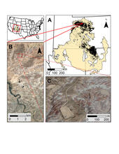
Location map of the Colorado Plateau ecoregion; ecoregion detail (A) with individual well sites identified by a black dot; Google Earth Pro aerial photography showing the footprint of oil and gas development at the landscape scale as small light colored patches (B); Google Earth Pro close-up of well pads and roads (C).
Sources/Usage
Public Domain.