
Water data visualizations are provocative visuals and captivating stories that inform, inspire, and empower people to address our Nation's most pressing water issues. USGS data science and visualization experts use visualizations to communicate water data in compelling and often interactive ways when static images or written narrative can’t effectively communicate the interconnectivity and complexity of a water data issue.
Related Information
-
2025 30-Day Chart Challenge Visualizations
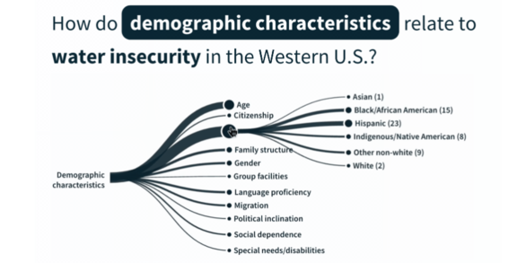
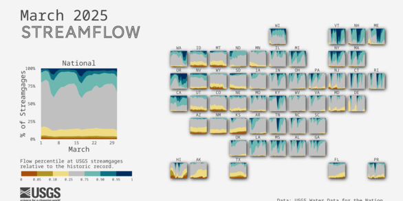
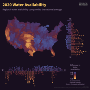
A month of data viz for the #30DayChartChallenge For the month of April, users are challenged to create daily data visualizations that fit within 5 major categories: comparisons, distributions, relationships, timeseries, and uncertainties. Each day, a unique prompt inspires participants to use a variety of chart types and get creative with their data. The USGS VizLab was excited to participate!
Water data visualizations are provocative visuals and captivating stories that inform, inspire, and empower people to address our Nation's most pressing water issues. USGS data science and visualization experts use visualizations to communicate water data in compelling and often interactive ways when static images or written narrative can’t effectively communicate the interconnectivity and complexity of a water data issue.
Related Information
-
2025 30-Day Chart Challenge Visualizations
A month of data viz for the #30DayChartChallenge For the month of April, users are challenged to create daily data visualizations that fit within 5 major categories: comparisons, distributions, relationships, timeseries, and uncertainties. Each day, a unique prompt inspires participants to use a variety of chart types and get creative with their data. The USGS VizLab was excited to participate!