
TRAILS: Advancing sustainable and user-focused trail planning
In 2024, we completed two major improvements to TRAILS (Trail Routing Analysis and Information Linkage System) – the improved route analysis tool and the addition of viewshed analysis feature.
The Trail Routing, Analysis, and Information Linkage System (TRAILS) is a geospatial trail planning tool that helps land managers identify and prioritize route connections using customizable criteria, including slope, transportation, water features, and waypoints.
In 2024, TRAILS underwent two major improvements in collaboration with our partners and the Esri development team:
- Sustainable Routing Enhancements: The routing tool was reworked to incorporate sustainable trail-building principles. By implementing a distance accumulation model, TRAILS now generates more accurate, environmentally friendly routes that align with natural contours.
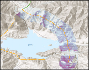
- Viewshed Analysis: A new viewshed analysis feature identifies areas visible along trail segments. This enhancement supports better decision-making by enabling users to prioritize scenic viewpoints, assess visual impacts, and improve the overall user experience.
These updates highlight our commitment to sustainability and usability, advancing TRAILS as a comprehensive tool for responsible and visually engaging trail planning.
The following images show before and after examples of a TRAILS project:


NOTE: Because of license limitations, access to the TRAILS application is limited to trail planners. See “Upcoming Training and Presentations” for access and TRAILS workshop information. Additionally, if you have had access in the past, email trails@usgs.gov for updated login instructions.