
New report ranks USGS assets high among Earth observations systems surveyed
Finds 73 USGS products support agriculture and forestry
The United States Group on Earth Observations, also known as USGEO, recently released its 2023 Earth Observation Assessment (EOA) report focused on agriculture and forestry.
Earth observation data related to agriculture and forestry applications are used to help inform daily decisions made in the field by farmers, ranchers, foresters, watershed, natural resource, and land managers, as well as by researchers.
The 2023 EOA Agriculture and Forestry report assesses the current portfolio of Earth observing systems in the U.S. to provide greater insight into specific uses of Earth observing data in delivering societal benefit in the areas of agriculture and forestry.
The data also highlight the role Earth observations play in helping to understand and address challenges faced within the agriculture and forestry sectors.

USGEO is co-chaired by the White House Office of Science and Technology Policy (OSTP), along with the U.S. Geological Survey (USGS), National Aeronautics and Space Administration (NASA), and the National Oceanic and Atmospheric Administration (NOAA). Its membership consists of Federal Agencies and components of the Executive Office of the President.
“The 2023 Earth Observation Assessment report underscores the importance of Earth observing data, from large government satellites to international, commercial, and in-situ network capabilities for addressing pressing societal challenges,” said Tim Newman, Program Coordinator for the USGS National Land Imaging Program. “By focusing on agriculture and forestry we aim to empower decision-makers with the information needed to make strategic investment decisions for sustained societal benefit.”
The assessment team collected information to determine the impacts of Earth observations on the agriculture and forestry sectors. They identified 1,172 Earth observation inputs and consulted 647 interdisciplinary subject matter experts to determine how existing observing systems support and provide societal benefits.
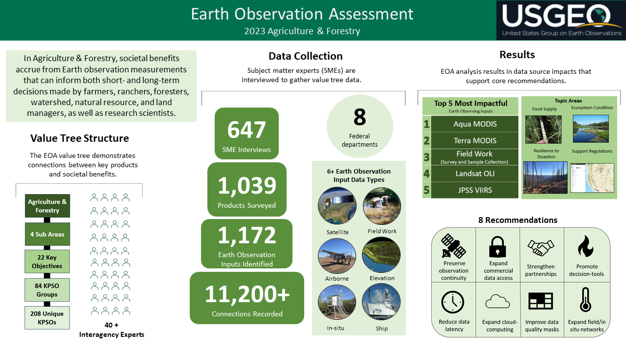
Several USGS observing systems ranked in the top 10% of most impactful Earth observation inputs. These systems include the Landsat missions, which support all 22 agriculture and forestry key objectives surveyed and the USGS streamgage network, which supports 35% of the objectives while providing data from over 10,000 stream and river locations across the Nation.
The report also highlights the interdependence and interagency use of USGS data. The 3D Elevation Program (3DEP), for example, provides key data in support of Landsat imagery pre-processing, and several USGS products that require high-quality Landsat images for work output which serves a multitude of agencies.

The team surveyed 1,039 Earth observation products, including, many from four of the five USGS mission areas: with 38 from Core Science Systems, 22 from Water Resources, 7 from Ecosystems and 6 from Natural Hazards Mission Areas. Given the Agriculture and Forestry focus, no products were identified within the Energy and Minerals Mission Area.
A total of 73 USGS products were recognized for their support to agriculture and forestry including the Landsat Provisional Actual EvapoTranspiration (ET), USGS QuickDRI, USGS ground water quality monitoring, the National Land Cover Database (NLCD), and the Rangeland Condition Mapping and Analysis Program (RCMAP). Many of these products provide critical support to decisionmakers for national interests such as enhancing food supply and disaster resilience.
The report identified the need for Earth observation data continuity, technology enhancement, partnerships, and collaboration in its recommendations. It also recommended expanded access to data and tools, and enhanced computing capacities for the robust and sustainable delivery of widespread societal benefits across agriculture and forestry applications. USGEO will continue to derive additional insights from the dataset to assess the impacts of Earth observation systems, data, and products. USGEO is completing an assessment report focused on the Climate societal benefit area which is expected later this year.
To access the EOA report in its entirety please visit: 2023 EOA for agriculture and forestry