
Plumbing the Depths of the Great Basin
Uncovering the hidden mineral potential under the Western Great Basin
Vast mineral wealth has been discovered in the Great Basin since the 1800s. As each new generation of prospectors and geologists brings their cutting-edge tools with them, the arid ridgelines of the desert Southwest have shown more and more potential.
Today, USGS Mineral Resources Program scientists are continuing that tradition, marrying the latest and greatest of assessment technology with a deep bedrock of geologic understanding and research. Here’s how:

Up in the Air to Look Deep Underground
One way of seeing underground is by flying high overhead. Airborne surveys using tools to measure the magnetic and electrical properties of the rock are a particularly effective method of surveying large areas at a reasonable resolution.
While sometimes these surveys can reveal specific mineral deposits, like rare earths, iron, or nickel, usually the geology is not so clear. Often what USGS scientists are hoping to achieve is to figure out groupings of various mineral types and rock layers. That way, as scientists learn more about how minerals form and group together, the magnetic and electrical readings can help show where likely candidates for producible mineral deposits might be found.
Airborne magnetic surveying is not the only way to acquire this data, naturally. Ground-based magnetic surveys are also conducted.
As on Top, So Below
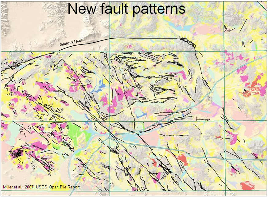
Although the saying goes “Don’t judge a book by its cover,” what’s on the surface can actually say a lot about what lies beneath. At least, that’s what USGS scientists are discovering as they look at the relationship between surface geologic features and subsurface geologic features.
Using geology, geochemistry, topography, and remote sensing, USGS scientists are producing maps of the various faults and fractures that lie beneath the Western Great Basin, linking them with the faults and features on the surface. Features like these help tell the story of how the Great Basin formed, and, in turn, what minerals might have formed in the process.

The More You Know...
So if all of this potential is deep underground, how can scientists accurately study it? By using models. All of the data that has been mentioned so far goes into complex but useful geologic models of the rock layers, rock types, and other features of the Great Basin.
Because of this, the more data that’s fed into a model, the more accurate (and useful) the model becomes. USGS scientists have been making sure that all available geology, as well as something called reverse remanent magnetism are incorporated into the geologic models.
Reverse remanent magnetism refers to the magnetization in rocks that formed when the magnetic field was reversed from what it is today. About half of all rocks at the Earth’s surface are formed with a remanent magnetic field reversed from the current Earth’s magnetic field and that can dramatically affect geophysical modeling.
This especially applies in the Great Basin, which contains large amounts of volcanic rocks high in feldspar and quartz from the Cenozoic period. USGS scientists can determine an approximate orientation of the remanent magnetic field using a magnetometer and oriented field samples.
Start with Science
All of this research will come together to give USGS scientists, as well as land and resource managers, as much information as possible about the potential mineral wealth of the Western Great Basin. As resource needs grow and minerals become ever more critical to the Nation’s security and economy, USGS minerals scientists will help ensure the Nation’s decision-makers have the best data available to them.
More Information:
-
Great Basin Metallogeny and Regional Structure: New Interpretations of Magnetic and Gravity Data (project website)
-
Geophysical Terrane of the Great Basin and parts of the surrounding provinces
-
Magmatic-Tectonic History and Component Sources of Major Precious Metal Deposits in the Southern Walker Lane (project website)
- Saltus and Jachens basement depth map
Get Our News
These items are in the RSS feed format (Really Simple Syndication) based on categories such as topics, locations, and more. You can install and RSS reader browser extension, software, or use a third-party service to receive immediate news updates depending on the feed that you have added. If you click the feed links below, they may look strange because they are simply XML code. An RSS reader can easily read this code and push out a notification to you when something new is posted to our site.