
Media Alert: Low-level flights to image geology over parts of south-central New Mexico
USGS low-level airborne surveys set to begin early September
Editor: In the public interest and in accordance with Federal Aviation Administration regulations, the USGS is announcing this low-level airborne project. Your assistance in informing the local communities is appreciated.
RESTON, Va. — Low-level fixed-wing and helicopter flights are planned over a broad region of central and southern New Mexico to image geology using airborne geophysical technology.
Three separate aircraft will be conducting the survey at different times from September 2024 through March 2025, weather and wildfire restrictions permitting.
Flights will cover areas within Lincoln, Otero, and Torrance Counties and cross the edges of Bernalillo, Chaves, and Socorro Counties.
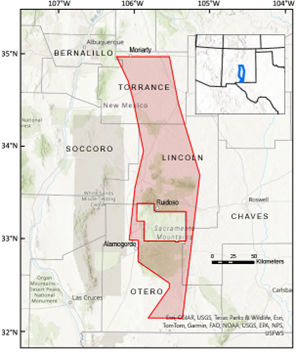
The flights will be based out of Alamogordo, Ruidoso, and Moriarty airports. The flights could shift with little warning to other parts of the survey area as necessitated by adverse flying conditions.
The purpose of the survey is to provide images that expand the fundamental knowledge of the geology underpinning the Texas-New Mexico alkaline igneous belt, where it extends northward from Texas to central New Mexico. The survey connects to a previous airborne geophysical survey over the Trans-Pecos region at the New Mexico-Texas border.
The three aircraft (two fixed-wing and one helicopter) will each fly along pre-planned flight paths relatively low to the ground at about 395 feet (120 meters) above the surface. The ground clearance will be increased to 1,000 feet (300+ meters) over populated areas and will comply with Federal Aviation Administration (FAA) regulations. Flights will follow east-west lines spaced about 650 feet (200 meters) apart and north-south lines about 6,560 feet (2 km) apart.
Each survey aircraft will be equipped with an elongated “stinger” mounted to the underside of the cabin, extending behind the fixed-wing planes and forward of the helicopter nose. Instruments in the stinger and inside the cabin will measure variations in the Earth’s magnetic field and natural low-level gamma energy created by different rock types.
The scientific instruments on each aircraft are completely passive, with no emissions that pose a risk to humans, animals, or plant life. No photography or video data will be collected. The data collected will be made freely available to the public once complete. The aircraft will be flown by experienced pilots who are specially trained and approved for low-level flying. The companies work with the FAA to ensure flights are safe and in accordance with U.S. law. The surveys will be conducted during daylight hours only.

The area of interest covers numerous focus areas that are prospective for critical mineral resources and is designed to assist with the mapping of subsurface features important for modeling groundwater resources. The survey footprint is coordinated with the New Mexico Bureau of Geology and Mineral Resources. Funding from the Bipartisan Infrastructure Law has facilitated coverage of such a large area.
The new geophysical data will be processed to develop high-resolution three-dimensional representations of bedrock composition and structure to depths more than 3,280 feet (1 kilometer) below the surface.
The 3D models and maps are important for improving our understanding of critical mineral resource potential, water resources, groundwater pathways near legacy mining areas, parameters for infrastructure and land use planning, and the potential risks of naturally occurring radon.
The survey fits into a broader effort by the USGS, the New Mexico Bureau of Geology and Mineral Resources and many other state geological surveys and other partners, including private companies, academics, and state and federal agencies to modernize our understanding of the Nation’s fundamental geologic framework and knowledge of mineral resources. This effort is known as the Earth Mapping Resources Initiative, and it includes airborne geophysical surveys like this one, geochemical reconnaissance surveys, topographic mapping using LiDAR technology, hyperspectral surveys, and geologic mapping projects.
The USGS is contracting with NV5 Geospatial, EDCON-PRJ, and Precision GeoSurveys to collect data.