
Media Alert: Low-level helicopter flights to image geology over parts of central and eastern Nevada
USGS Low-level helicopter surveys set to begin late August
Editor: In the public interest and in accordance with Federal Aviation Administration regulations, the USGS is announcing this low-level airborne project. Your assistance in informing the local communities is appreciated.
RESTON, VA. – Low-level Helicopter flights are planned over a broad region in Nevada to image geology using airborne geophysical technology. The survey will be conducted from early August to December 2024, weather and wildfire restrictions permitting.
Flights will occur over portions of Eureka, Nye, and White Pine Counties.

The flights will be based out of Ely Airfield (KELY) in Ely, Nevada. The survey base and flight locations are subject to change with little warning to other parts of the survey area as necessary to minimize ferrying distances and avoid adverse flying conditions
The purpose of the survey is to provide images that expand the fundamental knowledge of geology underpinning Nevada’s Great Basin region. This survey area was chosen due to its both known and suspected mineral occurrences. This includes Carlin type deposits, porphyry deposits (copper, molybdenum, silver, etc.), intrusion related gold deposits, rare metal granites, and lacustrine evaporites, which contain critical minerals.
The survey will help map rocks and minerals at the surface across vast regions that may have limited outcrop due to vegetation and unconsolidated rock cover. It will also help map subsurface geology, where some rocks can be located hundred to thousands of meters (more than 3280 feet) below the surface based on their magnetic signature. Such mapping can improve the understanding of the geologic framework within which the potential mineral resource may occur.
The new geophysical data will be processed to develop high-resolution three-dimensional representations of bedrock composition and structure to depths more than 3,280 feet (1 kilometer) below the surface.
The 3D models and maps are important for improving our understanding of critical mineral and geothermal resource potential, water resources, groundwater pathways near legacy mining areas, parameters for infrastructure and land use planning, and potential risks of naturally occurring radon.
The USGS is contracting with Woolpert Inc., who has subcontracted New Resolution Geophysics to collect data.
The helicopter will fly along pre-planned fight paths relatively low to the ground at about 300 feet (100 meters) above the surface. The ground clearance will be increased to 1,000 feet (300+ meters) overpopulated areas and will comply with Federal Aviation Administration (FAA) regulations. Flights will follow East-West lines spaced about 650 feet (200 meters) apart and North-South lines about 3,280 feet (1 km) apart.
The survey will use a Eurocopter AS350 B3 equipped with an elongated “stinger” mounted to the underside of the cabin extending forward from the helicopter. Instruments in the stinger and inside the cabin will measure variations in the Earth’s magnetic field and natural low-level gamma energy created by different rock types.
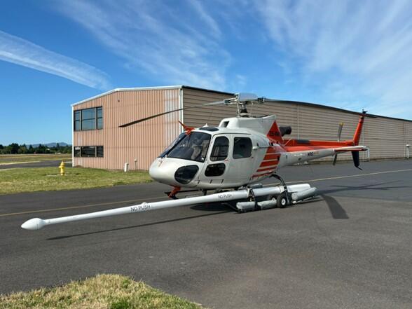
The scientific instruments on the helicopter are completely passive and do not emit any energy to aid in sensing, and so pose no risk to humans, animals, or plant life. No photography or video data will be collected. The data collected will be made freely available to the public once complete. The aircraft will be flown by experienced pilots who are specially trained and approved for low-level flying. The company works with the FAA to ensure flights are safe and in accordance with U.S. law. The surveys will be conducted during daylight hours only.
The survey fits into a broader effort by the USGS, the Nevada Bureau of Mines and Geology, and many other state geological surveys and other partners, including private companies, academics and state and federal agencies to modernize our understanding of the Nation’s fundamental geologic framework and knowledge of mineral resources. This effort is known as the Earth Mapping Resources Initiative, and it includes airborne geophysical surveys like this one, geochemical reconnaissance surveys, topographic mapping using LiDAR technology, hyperspectral surveys, and geologic mapping projects.
To read more about this project and others, visit our newsroom.
More information about the USGS Earth Mapping Resource Initiative (Earth MRI) can be found here. To learn more about how the USGS is investing the resources from the Bipartisan Infrastructure Law, visit our website. To learn more about USGS mineral-resource and commodity information, please visit our website.