Status of the Nationwide Digital Trails Dataset
Since the last newsletter, the USGS has added trails data from three states. The nationwide digital trails dataset is now up to 282,074 miles!
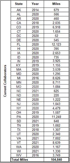
Since the last newsletter we added trails data from North Carolina State Parks (625 miles), VT Center for Geographic Information (8,639 miles), and Wisconsin Department of Natural Resources (1,330 miles). The nationwide digital trails dataset is now up to 282,074 miles thanks to our state partners! The dataset includes trails from four federal agencies, the Tennessee Valley Authority (TVA), and 35 states. The four federal agencies include Bureau of Land Management, National Park Service, U.S. Fish and Wildlife, and U.S. Forest Service. The table below details current state data contributors. Visit Trails Explorer to see the most current trails dataset.
NOTE: If you manage an authoritative public domain trail dataset that you think should be included in the nationwide dataset, please contact trails@usgs.gov.
Get Our News
These items are in the RSS feed format (Really Simple Syndication) based on categories such as topics, locations, and more. You can install and RSS reader browser extension, software, or use a third-party service to receive immediate news updates depending on the feed that you have added. If you click the feed links below, they may look strange because they are simply XML code. An RSS reader can easily read this code and push out a notification to you when something new is posted to our site.


