
Volcano Watch — Mount St. Helens still erupting as anniversary approaches
After 18 years of relative quiet between 1987 and 2004, Mount St. Helens volcano began erupting again nearly one year ago with a small but spectacular explosion.
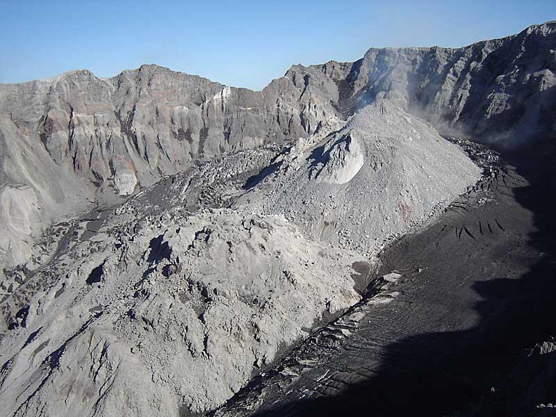
Since then, lava oozing onto the volcano's crater floor has added at least 58 million cubic meters (76 million cubic yards) of new material to the lava dome that grew in the crater between 1980 and 1986. The lava dome is a craggy mound-shaped pile of fresh lava nestled in the crater.
When the first series of shallow earthquakes struck beneath the volcano on September 23, no one imagined that an eruption would occur within a week, let alone still be going a year later.
In the past 12 months, scientists of the Cascades Volcano Observatory and University of Washington have focused attention on tracking and understanding the volcano's activity.
They've designed and deployed a variety of volcano instruments to monitor the activity closely, given thousands of media interviews to keep the public informed of the eruption and potential eruption scenarios, and dedicated many extra hours watching the volcano around the clock to ensure that emergency-response officials are fully informed about what is occurring and what could potentially occur.
When the activity began suddenly a year ago on September 23 the swarm of earthquakes initially looked like other swarms at Mount St. Helens that had not led to an eruption. The earthquakes peaked at 2 to 3 per minute the next day and gradually began to decline.
But on September 25, the shallow earthquakes increased in size and rate. By October 1, earthquakes were occurring nearly continuously. Peak earthquake sizes reached a magnitude of 3.5 and earthquakes larger than magnitude 2.5 occurred about once a minute.
At the same time, scientists noticed that the glacier on the crater floor south of the lava dome was seriously cracked. They estimated that it had been pushed upward as high as 10 or more meters (yards). The deformed glacier and earthquakes were evidence that magma was moving toward, and probably very near, the surface.
The first explosion on October 1 lasted about 25 minutes and was witnessed live via television by hundreds of thousands of people around the world. The explosion occurred from the base of the dome near where the glacier was cracked and uplifted. Three more small explosions occurred by October 5.
In early October, scientists measured the presence of volcanic gases (carbon dioxide, sulfur dioxide, and hydrogen sulfide) and recorded the continued disruption and uplift of the glacier on the south side of the dome and the south part of the dome itself.
Finally, on October 11, scientists were able to confirm that lava had punctured the surface when a spine of hot, fresh lava 30 m tall (100 ft) rose from the old dome next to the fractured glacier.
During the next few months, lava extruding from the area of the first spine extended as a solid mass toward the southeast, much like a giant piston being pushed up from the ground. Continued extrusion of lava created an enormous feature that scientists called a "whaleback," because it appeared smooth and elongate and moved like a very slow, arching whale.
The first whaleback grew to about 500 m (1,640 ft) long and 200 m wide (650 ft) in December. Instruments placed on the whaleback showed that it moved had southward as much as 10 m (35 ft) per day in November 2004. A second whaleback that formed slowed to about 6 m (20 ft) per day in February 2005.
These early whaleback features disintegrated earlier this summer, but lava continued to build spines and add new material progressively to the southwest of the old dome. Several time-lapse cameras installed on the crater rim are helping to track the complex growth of the new dome.
No one knows how long the eruption will continue.
The sudden onset of activity at Mount St. Helens a year ago and the prolonged eruption are not unusual. Kīlauea's eruption is now in its 22nd year! Both show that constant and determined vigilance is required by scientists to respond effectively to ongoing and developing volcano emergencies.
Volcano Activity Update
Eruptive activity at Pu`u `O`o continues. On clear nights, glow is visible from several vents within the crater and on the southwest side of the cone. Lava continues to flow through the PKK lava tube from its source near Pu`u `O`o to the ocean, with very few surface flows breaking out of the tube. Small flows are visible intermittently on the steep slope of Pulama pali and on the coastal plain. As of September 1, lava is entering the ocean at East Lae`apuki.
A large bench collapse at East Lae`apuk began at 01:33 a.m. on August 27 and continued for over an hour. About 12.5 acres of bench disappeared-a segment about 500 m long by 150 wide. A local tsunami generated by the collapse washed boulders as large as 1 m in diameter onto the remaining bench. Access to the ocean entry and the surrounding area remains closed due to significant hazards. If you visit the eruption site, check with the rangers for current updates, and remember to carry lots of water when venturing out onto the flow field.
During the week ending August 31, three earthquakes were felt on Hawai`i Island. A magnitude-2.0 quake at 10:37 PM on August 29 was located 36 km (22 miles) northwest of Hilo at a depth of 10 km (6 miles) and was felt in Hawi. The second event at 4:52 AM on August 30 was located 11 km (7 miles) west of Honoka`a at a depth of 26 km (16 miles) was felt in Waimea. A third earthquake felt in Leilani Estates was a magnitude-2.0 event located 5 km (3 miles) southeast of Pahoa at a depth of 4 km (2.5 miles).
Mauna Loa is not erupting. During the week ending August 31, ten earthquakes were recorded beneath the summit area. Three were deep, long-period events and seven were shallow. Inflation of the summit area continues.
Get Our News
These items are in the RSS feed format (Really Simple Syndication) based on categories such as topics, locations, and more. You can install and RSS reader browser extension, software, or use a third-party service to receive immediate news updates depending on the feed that you have added. If you click the feed links below, they may look strange because they are simply XML code. An RSS reader can easily read this code and push out a notification to you when something new is posted to our site.