U.S. flag

An official website of the United States government

June 21, 2022

An eruption at Kīlauea's summit began at approximately 3:20 p.m. HST on September 29, 2021. Lava activity is confined within Halema‘uma‘u crater, in the closed area of Hawai‘i Volcanoes National Park.

HVO scientists collect detailed data to assess hazards and understand how the eruption is evolving at Kīlauea's summit, all of which are shared with the National Park Service and emergency managers. Access to this hazardous area is by permission from, and in coordination with, Hawai‘i Volcanoes National Park.

June 15, 2022 — Small collapse into lava lake at Kīlauea summit

The lava lake in Halema‘uma‘u, at the summit of Kīlauea, remains active. On Wednesday, June 15, a small collapse of a portion of the lake rim created a dusty plume and lake agitation, including waves that traveled across the lake surface. 

June 17, 2022 — Kīlauea summit eruption ongoing

Overview of Halema‘uma‘u lava lake

Color photograph of lava lake
An image of Halema‘uma‘u taken during a Kīlauea summit helicopter overflight on the morning of June 17, 2022. There are several areas of degassing (the small white plumes) located across the lake surface, some of which are associated with hornitos. Hornitos are small, rootless cones that are fed by the tube network within the lava lake. The active portion of the lava lake is located on the western side of the lake (right side of the photograph). The Hawai‘i Volcanoes National Park eruption public viewing area at Keanakāko‘i can be seen in the upper left of the photograph. USGS photograph by L. Gallant.

Hornitos on the surface of Halema‘uma‘u

Color photograph of lava lake
Two hornitos degassing on the surface of Halema‘uma‘u, taken during a Kīlauea summit helicopter overflight on the morning of June 17, 2022. Hornitos are small, rootless cones that are fed by the tube network within the lava lake. These features are several tens of feet tall (less than 30 meters). Hornitos are more prevalent on the eastern side of Halema‘uma‘u, where the tube network beneath the crust controls the movement of lava within the crusted over lake in this sector of the summit area. USGS photo by L. Gallant.

Kīlauea summit eruption map

Color map of eruption at summit of volcano
This reference map depicts the ongoing Kīlauea summit eruption on June 21, 2022. One eruptive vent (orange) is active within Halema‘uma‘u, on the western side of the crater floor. An adjacent pond (purple) is feeding lava to a larger lake (red); though at times the lava level has dropped and circulation has diminished, the pond and lake have consistently hosted active lava in recent weeks. The eruption statistics provided here are current as of the last HVO overflight on June 17, 2022. Unlike the median elevation reported in several of the most recent eruption reference maps, this map provides a volume-averaged elevation for the crater floor—2,854 feet (870 meters) above sea level—and its rise since September 29, 2021. Lava is presently visible from three public visitor overlooks in Hawai‘i Volcanoes National Park: Keanakāko‘i Overlook and Kūpina‘i Pali (Waldron Ledge) can see the eruptive vent and lava lake, while Kīlauea Overlook can occasionally see lava ooze-outs in the southeast part of the crater. Visit the park eruption page for more info: https://www.nps.gov/havo/learn/nature/september-2021-eruption.htm.

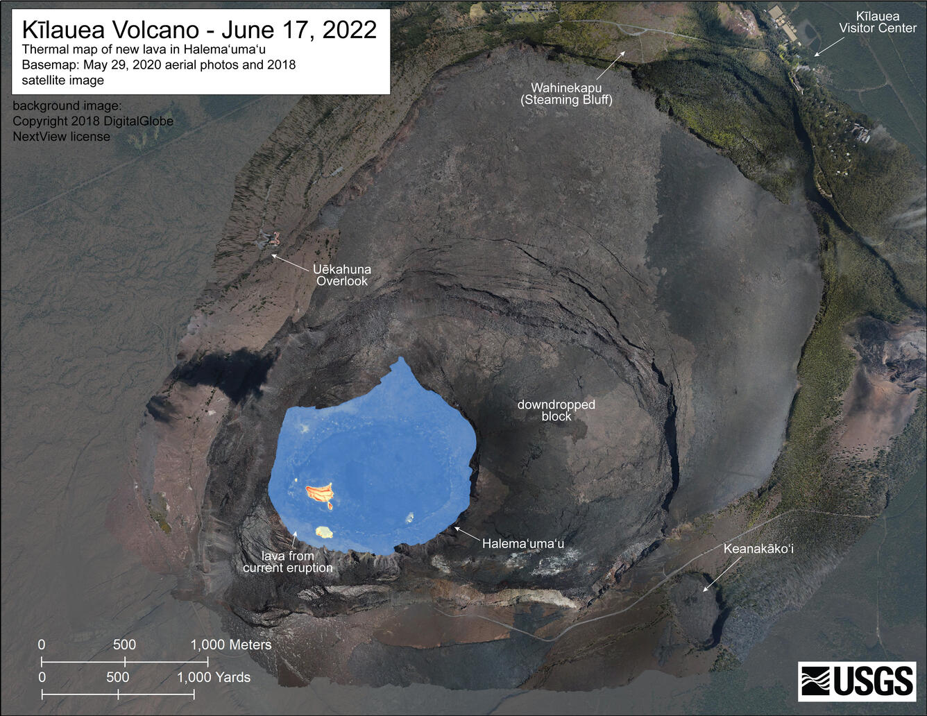
Kīlauea summit thermal map

Color map of lava lake temperature
A helicopter overflight on June 17, 2022, allowed for aerial visual and thermal imagery to be collected of Halema‘uma‘u crater at the summit of Kīlauea. The active lake surface is limited to the western portion of the crater. The scale of the thermal map ranges from blue to red, with blue colors indicative of cooler temperatures and red colors indicative of warmer temperatures. 
Color map of lava lake temperature
A helicopter overflight on June 17, 2022, allowed for aerial visual and thermal imagery to be collected of Halema‘uma‘u crater at the summit of Kīlauea. The active lake surface is limited to the western portion of the crater. The scale of the thermal map ranges from blue to red, with blue colors indicative of cooler temperatures and red colors indicative of warmer temperatures. USGS map.

Get Our News

These items are in the RSS feed format (Really Simple Syndication) based on categories such as topics, locations, and more. You can install and RSS reader browser extension, software, or use a third-party service to receive immediate news updates depending on the feed that you have added. If you click the feed links below, they may look strange because they are simply XML code. An RSS reader can easily read this code and push out a notification to you when something new is posted to our site.

Was this page helpful?