An official website of the United States government
Here's how you know
Official websites use .gov
A .gov website belongs to an official government organization in the United States.
Secure .gov websites use HTTPS
A lock () or https:// means you’ve safely connected to the .gov website. Share sensitive information only on official, secure websites.
Kīlauea volcano's middle East Rift Zone eruption resumed late on September 16, 2024, and it continues this morning within Nāpau Crater. The eruption is located in a remote and closed area of Hawaiʻi Volcanoes National Park.
Kīlauea volcano's middle East Rift Zone eruption resumed late on September 16, 2024, and it continues this morning within Nāpau Crater in Hawaiʻi Volcanoes National Park. USGS Hawaiian Volcano Observatory geologists conducted an aerial overflight to document the eruption and assess hazards. The Volcano Alert Level for ground-based hazards remains at WATCH and the Aviation Color Code remains at ORANGE at this time. Rates of seismicity and ground deformation beneath the summit, lower East Rift Zone, and Southwest Rift Zone remain low.
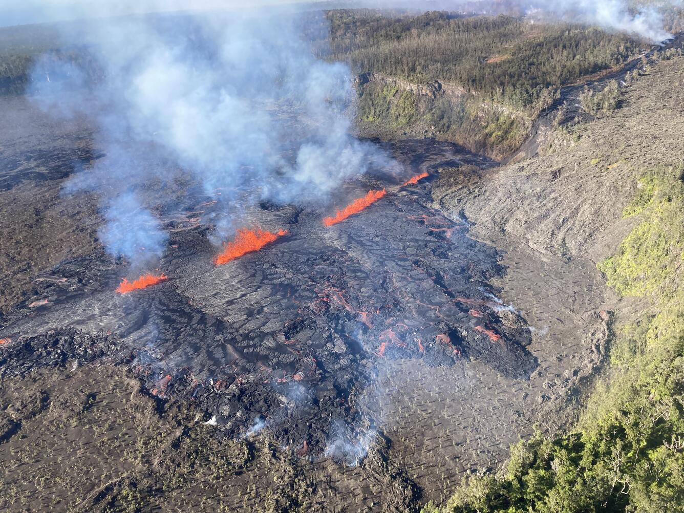
This photograph of Kīlauea's ongoing middle East Rift Zone eruption was captured during a Hawaiian Volcano Observatory helicopter overflight during the morning of September 17, 2024. This photo was taken at 8:11 am H.S.T. Geologists observed fountaining eruptive fissures and active lava flows bisecting the floor of Nāpau Crater, just downrift (northeast) of the September 15 eruptive fissure. This south-facing view shows the current activity from the west side of the crater. USGS photo by N. Deligne.
Kīlauea volcano is erupting in Hawai’i Volcanoes National Park from a new fissure vent that opened within Nāpau Crater this morning, September 17, between 4:00 and 5:00 AM HST. The eruption is occurring within a closed and remote area of Hawaiʻi Volcanoes National Park. This morning, several lava fountains approximately ten meters (yards) high are generating lava flows on the floor of Nāpau Crater. Currently, the fissure system in Nāpau is about 0.5 km long (.3 mi) and cuts east-west across the northern crater floor. As of 8:30 AM, approximately 25-30% of Nāpau Crater floor has been covered by lava, which is confined to the crater. USGS photo by K. Mulliken.
Current activity is restricted to Kīlaueaʻs upper-to-middle East Rift Zone, in a remote and closed area of Hawaiʻi Volcanoes National Park. Chain of Craters Road, which is closed, is located downslope and downwind of the new fissures. Continued gas emissions from the eruptive fissures may pose a hazard to humans downwind of the eruption site. However, due to the remote location, the eruption does not currently pose an immediate threat to human life or infrastructure.
This photograph of Kīlauea's ongoing middle East Rift Zone eruption was captured during a Hawaiian Volcano Observatory helicopter overflight during the morning of September 17, 2024. This low-angle view looking southwest shows three lava fountains; the tallest is approximately 10 meters (30 feet) high. The dark black lava covering the floor of Nāpau Crater erupted within the 12-14 hours prior to this photo was taken at 8:09 am H.S.T. An older spatter rampart is visible in the lower left of the photo. USGS photo by N. Deligne.
This photograph of Kīlauea's ongoing middle East Rift Zone eruption was captured during a Hawaiian Volcano Observatory helicopter overflight during the morning of September 17, 2024. Geologists observed fountaining eruptive fissures and active lava flows on the floor of Nāpau Crater, just downrift (northeast) of the September 15 eruptive fissure. This south-facing view shows the current activity from the north side of Nāpau Crater. USGS photo by A. Ellis.
HVO is continuing to closely monitor the middle East Rift Zone and in contact with Hawai‘i Volcanoes National Park and the Hawai‘i County Civil Defense Agency. Temporary closures have been implemented as a result of this eruption; please see the Hawaiʻi Volcanoes National Park website for visitor information: https://www.nps.gov/havo/index.htm.
This photograph of Kīlauea's ongoing middle East Rift Zone eruption was captured during a Hawaiian Volcano Observatory helicopter overflight during the morning of September 17, 2024. This photo was taken at 7:30 am H.S.T. Geologists observed fountaining eruptive fissures and active lava flows bisecting the floor of Nāpau Crater, just downrift (northeast) of the September 15 eruptive fissure. The active (foreground) and inactive (upper middle) fissures are emitting volcanic gases, which appears white. At the northern (right) lava flow margin there is also steam associated with localized minor burning of vegetation. The slope of Mauna Loa is visible in the background (right). This southeast-facing view shows the current activity from the northwest side of the crater. USGS photo by N. Deligne.
Numerous eruptions took place in Kīlauea's middle East Rift Zone during the 1960s–1970s. Most of these eruptions occurred between Hiʻiaka crater and Puʻuʻōʻō and lasted from less than one day to about two weeks, although there were long-lived eruptions at Maunaulu (1969–1971 and 1972–1974) and Puʻuʻōʻō (1983–2018). A map of past eruptive activity in the upper-to-middle East Rift Zone of Kīlauea is available here: https://www.usgs.gov/maps/kilauea-middle-east-rift-zone-reference-map.
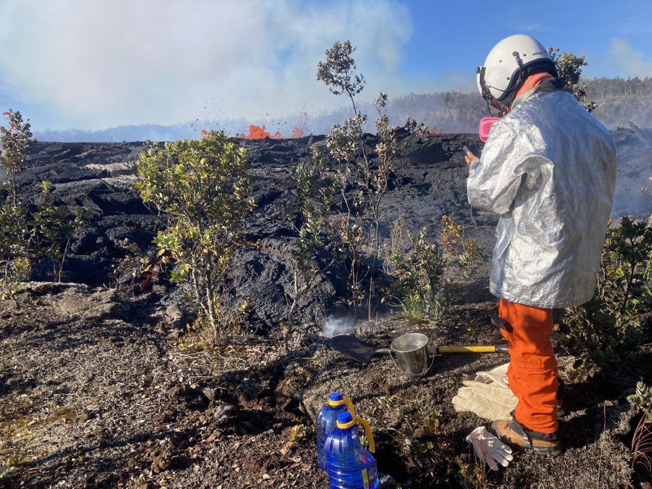
(Video) USGS Hawaiian Volcano Observatory geologists collected a sample of the middle East Rift Zone Kīlauea eruption in Nāpau Crater, within a closed area Hawaiʻi Volcanoes National Park. Geologists put molten lava into a metal bucket and rapidly quench it with water. The fast quench is needed to preserve the geochemistry of the fresh sample and prevent changes that would result from the formation of crystals during slow cooling. The samples will be taken to the lab for analysis, providing scientists with information about conditions in the magma chamber and magma's path to the surface. USGS image by A. Ellis.
This photograph of Kīlauea's ongoing middle East Rift Zone eruption was captured during a Hawaiian Volcano Observatory helicopter overflight during the morning of September 17, 2024. Geologists observed fountaining eruptive fissures and active lava flows bisecting the floor of Nāpau Crater, just downrift (northeast) of the September 15 eruptive fissure. This east-facing view shows the current activity from the west side of the crater. USGS photo by A. Ellis.
This photograph of Kīlauea's ongoing middle East Rift Zone eruption was captured during a Hawaiian Volcano Observatory helicopter overflight during the morning of September 17, 2024. Fissures from the previous day's eruption continued to emit steam and gases while new fissures erupted fresh lava in Nāpau Crater. USGS photo by A. Ellis.
(Photo) USGS Hawaiian Volcano Observatory geologists collected a sample of the middle East Rift Zone Kīlauea eruption in Nāpau Crater, within a closed area Hawaiʻi Volcanoes National Park. Geologists put molten lava into a metal bucket and rapidly quench it with water. The fast quench is needed to preserve the geochemistry of the fresh sample and prevent changes that would result from the formation of crystals during slow cooling. The samples will be taken to the lab for analysis, providing scientists with information about conditions in the magma chamber and magma's path to the surface. USGS image by A. Ellis.
An early morning view of the plume of volcanic gas being emitted by the eruption on Kīlauea’s middle East Rift Zone. This view, from Halapē campground on the coast in Hawaiʻi Volcanoes National Park, shows the plume being transported downwind in a southwest direction. Much of the plume consists of sulfur dioxide (SO2), which will mix with air as it moves away from the vent. USGS photo by J. Sutton.
A view under the plume of volcanic gas being transported by wind southwest from the eruption in Nāpau Crater on the middle East Rift Zone of Kīlauea. With permission from Hawaiʻi Volcanoes National Park, USGS Hawaiian Volcano Observatory gas specialists are traversing under the plume using a vehicle-mounted ultraviolet spectrometer on the closed portion of Chain of Craters Road, to quantify the amount of sulfur dioxide (SO2) being emitted during the eruption. SO2 emission rates are a key parameter to measure, as they can be used as a proxy for lava effusion rate and they dictate how much vog, or volcanic air pollution, there is downwind. USGS image by T. Nadeau.
New webcam on middle East Rift Zone
Live view of Nāpau Crater on the East Rift Zone of Kīlauea, view is to the southwest [S2cam]
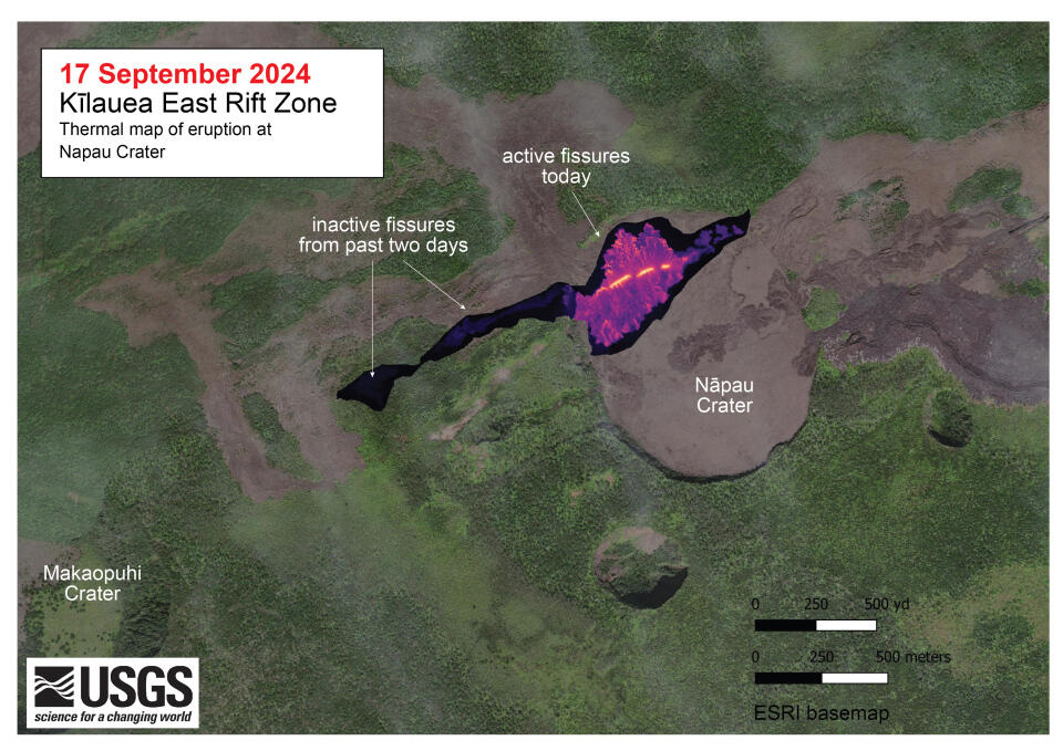
A helicopter overflight on September 17, 2024, allowed for aerial visual and thermal imagery to be collected at the middle East Rift Zone eruption site on Kīlauea. The eruptive activity continues with fountains active within Nāpau Crater and lava flowing on the crater floor, marking an eastward shift in activity compared to September 15. The scale of the thermal map ranges from blue to red, with blue colors indicative of cooler temperatures and red colors indicative of warmer temperatures.
This reference map depicts fissures and lava flows from the Kīlauea middle East Rift Zone eruption on Tuesday, September 17, 2024. The presented data are current as of the final Hawaiian Volcano Observatory helicopter overflight of the day, which occurred at approximately 10:30 a.m. Areas in bright red represent new lava flows from the evening of September 16 and morning of September 17, when activity was focused on the floor of Nāpau Crater. In total, the fissure system has stretched over 1.6 kilometers (1.0 miles) of the East Rift Zone, with lava flows now covering 18 hectares (44 acres).