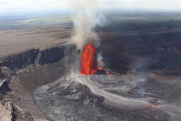
U.S. flag

An official website of the United States government

April 2, 2025

The high fountain phase of episode 16 of the ongoing Halemaʻumaʻu eruption began at 10:24 a.m. HST on April 1, 2025, about 12 hours after the start of the episode. Fountaining from the south vent rapidly increased to over 200 feet (70 meters) in height by 10:40 a.m. HST and exceeded 700 feet (215 m) by 10:50 a.m. HST. Low dome fountaining and overflows continue from the north vent. 

Aerial video of Kīlauea summit eruption episode 16 lava fountain and its lava flow on April 1, 2025, taken during a USGS Hawaiian Volcano Observatory monitoring overflight at approximately noon. The lava fountain was reaching heights of more than 650 ft (200 m) at times and feeding a lava flow that as of noon on April 1 reached about 2,300 ft (700 m) from its vent. The lava fountain was also depositing a tephra blanket to the northwest that was reaching Highway 11. In some places near the vents, the tephra deposit is up to 5 ft (1.5 m) thick and represents accumulation of 16 eruptive episodes since December 23, 2024. 
Media
Color photograph of lava fountain
Helicopter overflight view of episode 16 lava fountain and its lava flow on the crater floor of Kaluapele at around noon on April 1, 2025. The lava flow at this time had traveled 2,300 ft (700 m) from the fountain along the floor of Halemaʻumaʻu. USGS photo by D. Downs.
Media
Color photograph of eruption and growing deposit
Kīlauea summit lava fountain from the west end of Halemaʻumaʻu and the tephra blanket it has produced through its 16 episodes. In some places, the tephra blanket reaches more than 5 ft (1.5 m) thick. Most of the tephra from episode 16 lava fountain on April 1, 2025, was blowing to the northwest, with some clasts reaching Highway 11. USGS photo by D. Downs.
Media
Color photograph of lava fountain
USGS Hawaiian Volcano Observatory geologist captured this aerial view during a monitoring helicopter overflight of episode 16 at around noon on April 1, 2025.  The lava fountain feeds a lava flow from the western end of Halemaʻumaʻu. This lava fountain reached heights of more than 650 ft (200 m) high and was blanketing the western part of the summit to Highway 11 with tephra clasts. Clasts were larger closer to the fountain. USGS photo by D. Downs.
Media
Color photograph of eruption and volcanologist
On April 1, lava fountains from Kīlauea's ongoing summit eruption prevented geologists from accessing the rim of Halemaʻumaʻu crater within the closed portion of Hawaiʻi Volcanoes National Park. Instead, they hung back along the closed portion of Crater Rim Drive to collect samples of tephra that was intermittently blown in their direction. Here, a USGS Hawaiian Volcano Observatory geologist watches over the tephra fallout zone from the eruption, waiting for wind conditions to permit sample collection. USGS photo by M. Zoeller.
Media
Color photograph of lava fountain
On April 1, a USGS Hawaiian Volcano Observatory geologist captured this zoomed-in photo of the upper portion of the active lava fountain during Kīlauea's ongoing summit eruption. Here, one can see the origin of tephra that has blanketed areas downwind of the eruptive vents during this eruption: while molten spatter (red) falls quickly back to earth, solid but frothy pieces of lava (black) loft higher in the plume, buoyed by hot gases escaping the eruptive vent. USGS photo by M. Zoeller. 
Media
Color photograph of a lava fountain
Late in the evening on April 1, USGS Hawaiian Volcano Observatory geologists watched the ongoing Kīlauea summit eruption from Kūpinaʻi Pali (Waldron Ledge). This view of the active eruptive vents was captured through the lens of a laser rangefinder device the geologists were using to measure lava fountain heights. USGS photo by M. Zoeller. 
Media
Color photograph of volcanic plume
Episode 16 lava fountains were visible from Highway 11 in Kaʻū on April 1. In this view, the top of the lava fountain is just visible above Halemaʻumaʻu crater rim, and Uēkahuna (the highest part of the caldera rim) is visible to the left. USGS photo by K. Mulliken. 
Media
Color photograph of eruption plume
The episode 16 eruption plume was transported north-northwest on April 1, over Highway 11 in Kaʻū. USGS Hawaiian Volcano Observatory volcanic gas specialists traversed under the plume on the highway in order to get a sulfur dioxide emission rate for episode 16. Based on six traverses, they obtained an average emission rate of 50,000 tonnes per day of sulfur dioxide, which is in line with other measurements and emission rate estimates for other recent eruption episodes at Kīlauea summit. USGS photo by K. Mulliken. 
Media
Color photograph of road with tephra on the side
Episode 16 lava fountains deposited tephra and Pele's Hair on Highway 11 in Kaʻū on April 1. In this photo, taken around 3:30 p.m. HST, the tephra and Pele's Hair is visible along the centerline and on the shoulder of the highway. USGS photo by K. Mulliken. 
Media
Color photograph of rocks on road
Wind conditions during episode 16 of the Kīlauea summit eruption resulted in material from the lava fountains being deposited on Highway 11 on April 1. This photo shows the amount of material, including tephra and Pele's Hair, that had accumulated by 3:30 p.m. HST. A Hawaii County Civil Defense Agency message at 12:49 p.m. HST stated, "If you are in this area, please do not stop, do not get out of your vehicle, and keep your window fully rolled up." USGS photo by K. Mulliken. 
Media
Color photograph of caldera with eruption within it
USGS Hawaiian Volcano Observatory geologists captured this aerial view of Kīlauea summit on April 1, 2025, during a helicopter overflight about 3 hours after high fountaining started during episode 16 of the ongoing eruption. USGS photo by N. Deligne.

Episode 15 timelapse video

This timelapse video shows lava fountaining during episode 15 of the summit eruption at Kīlauea volcano. The sequence starts with small filling-draining cycles in the vent that abruptly shift into major fountaining. The inclination of the fountain changes repeatedly, depositing lava in varying directions around the vent. The fountaining ceases as abruptly as it started, consistent with earlier episodes. USGS video by M. Patrick.


Get Our News

These items are in the RSS feed format (Really Simple Syndication) based on categories such as topics, locations, and more. You can install an RSS reader browser extension, software, or use a third-party service to receive immediate news updates depending on the feed that you have added. If you click the feed links below, they may look strange because they are simply XML code. An RSS reader can easily read this code and push out a notification to you when something new is posted to our site.

Was this page helpful?