
A new Kīlauea eruption began in a remote area of Hawaiʻi Volcanoes National Park on Sunday, September 15, 2024. This is the first eruption on Kīlauea’s middle East Rift Zone (MERZ) since 2018 and it poses no immediate threat to life or infrastructure. The USGS Hawaiian Volcano Observatory (HVO) is closely monitoring this eruption.
Volcano Watch is a weekly article and activity update written by U.S. Geological Survey Hawaiian Volcano Observatory scientists and affiliates.
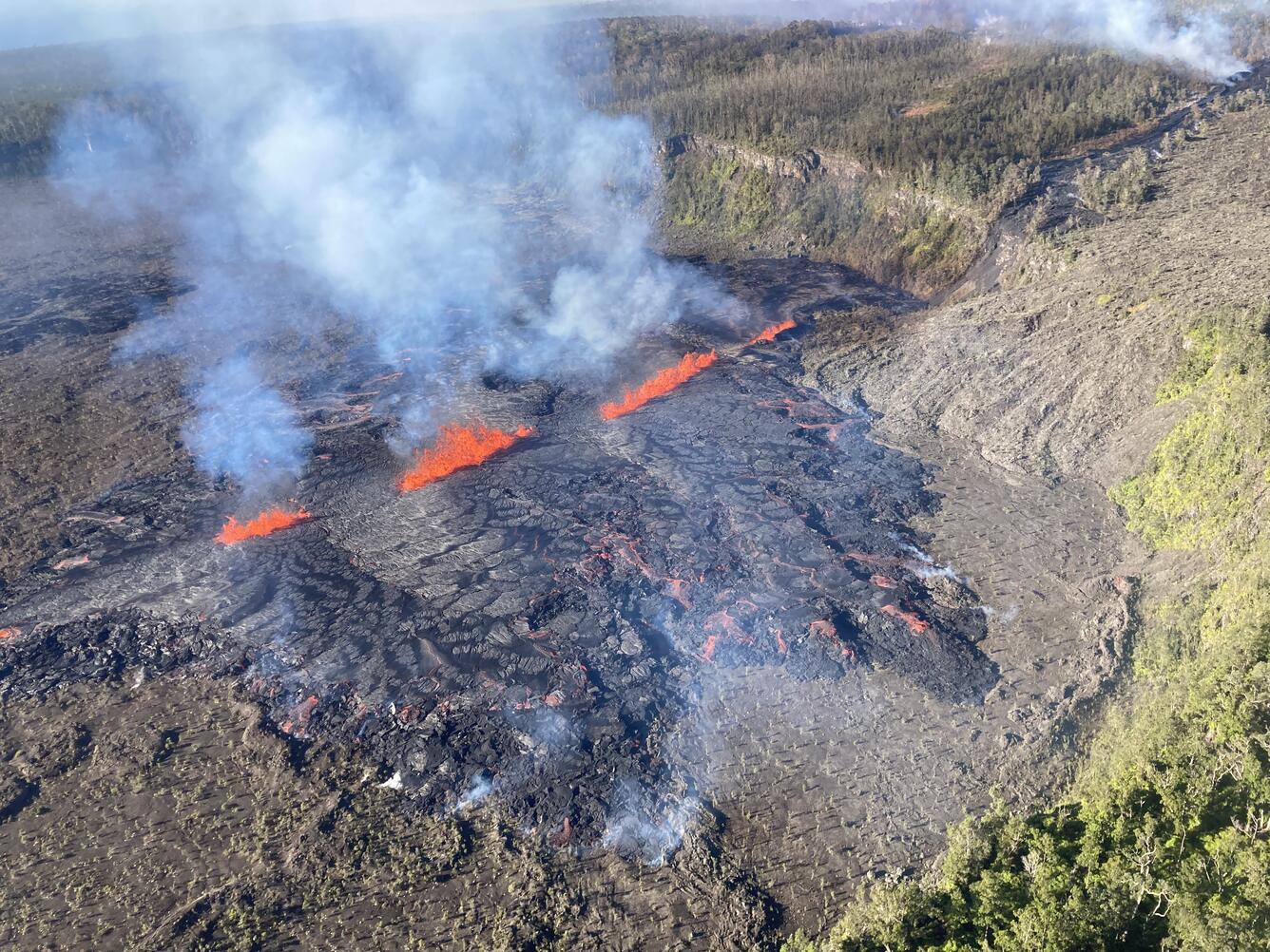
HVO has been in close contact with Hawai‘i Volcanoes National Park and the Hawai‘i County Civil Defense Agency throughout this eruption, which has featured a series of small fissure phases that have each lasted from hours to days. Each phase has increased in volume with the most recent being the largest to date. In total, the fissure system has stretched over 1.8 km (1.1 miles), and lava has covered more than 630,000 square meters (156 acres).
The first phase of the eruption began between 9 and 10 p.m. HST on Sunday evening. Infrasound sensors in HVO’s monitoring network recorded strong signals indicative of gas or steam venting. At the same time, HVO’s seismometers recorded weak but sustained low frequency tremor. Although an eruption could not be confirmed visually Sunday night by webcams or satellite thermal data due to heavy rainfall, the geophysical data indicated that an eruption could be taking place. That night, some residents in nearby communities also reported strong sulfur or burning smells.
The next morning, Monday, September 16, HVO scientists on a helicopter overflight confirmed that a small eruption had occurred on Kīlauea’s MERZ between Makaopuhi Crater and Nāpau Crater. This first fissure eruption was small and covered less than 4 acres. Lava was no longer flowing on the surface as of Monday, but magma was still moving underground as detected by seismometers, tiltmeters and GPS.
Phase two of the eruption began Monday evening around 6 p.m. HST. The onset of this eruptive activity was detected in NOAA GOES satellite thermal imagery and HVO webcam imagery. Interestingly, no changes were detected in other monitoring datasets. Fissures from this phase of the eruption produced lava fountains and flows that gradually decreased through the night. But activity would soon resume.
The third eruptive phase then began between 4 and 5 a.m. HST on Tuesday, September 17. This onset was detected using a combination of infrasound signals, GOES satellite thermal anomaly, and webcam imagery. After sunrise, HVO scientists on a helicopter overflight observed several lava fountains approximately 10 meters (yards) high that were generating lava flows on the floor of Nāpau Crater. This eruptive phase was more vigorous and longer lived and continued and gradually decreasing levels through Wednesday afternoon.
A fourth eruptive phase began around 3 p.m. HST on Wednesday, September 18, as new fissures opened west of Nāpau Crater. A monitoring camera deployed by HVO field crews with permission from Hawaiʻi Volcanoes National Park recorded “lava falls” cascading down the northwest walls of Nāpau Crater. Vigorous activity continued into Wednesday evening and lava continues to cascade into Nāpau Crater as of Thursday morning, September 19.
The eruption continues as this article is published. HVO webcam views are available from our website including a new live view of Nāpau Crater. How long will the eruption last? Examining history, numerous MERZ eruptions took place during the 1960s–1970s, most of which lasted less than one day to about two weeks. An eruption near Nāpau Crater in 1997 lasted two days. The nearby 2011 Kamoamoa eruption lasted five days. Of course, there have also been much longer-lived MERZ eruptions as well. Maunaulu lasted five years and Puʻuʻōʻō lasted 35 years. Time will tell!
Looking at the bigger picture, this eruption signals a significant and fascinating change in activity at Kīlauea. One year ago this week, a Kīlauea summit eruption in Halemaʻumaʻu was just ending. That eruption, which lasted from September 10-16, 2023, was the fifth in a series of eruptions within Halemaʻumaʻu since December 2020. On June 3, 2024, the first Kīlauea eruption outside the summit caldera since 2018 occurred several miles southwest of Halemaʻumaʻu. And now, after a series of seismic swarms and magmatic intrusions beneath the upper East Rift Zone over the past few months, we are witnessing the first MERZ eruption since 2018. It seems that a new era of Kīlauea eruptions has begun.
Volcano Activity Updates
Kīlauea is erupting. Its USGS Volcano Alert level is WATCH.
On Saturday, September 14, magma intruded into the middle East Rift Zone region of Kīlauea. A brief eruption occurred the night of September 15, just west of Nāpau Crater within Hawaiʻi Volcanoes National Park. The eruption resumed late in the day on September 16, and continued through the night, decreasing in vigor until about 4 a.m. HST, September 17, when new vents opened to the east in Nāpau Crater. At 3:15 p.m. HST on September 17, the Nāpau Crater vents likely ceased, with eruptive activity shifting west of the crater and generating lava flows over the northwest wall and into Nāpau Crater. Multi-day fissure eruptions in this area are not unusual and current eruptive activity appears to be linked to supply of magma from the summit. The most recent sulfur dioxide emission rate for the eruption was 10,000 tonnes per day, measured on September 18.
Mauna Loa is not erupting. Its USGS Volcano Alert Level is at NORMAL.
Two earthquakes were reported felt in the Hawaiian Islands during the past week: a M3.1 earthquake 23 km (14 mi) W of Volcano at 8 km (5 mi) depth on September 15 at 1:15 p.m. HST and a M4.3 earthquake 6 km (3 mi) SSW of Volcano at 0 km (0 mi) depth on September 14 at 4:25 p.m. HST.
HVO continues to closely monitor Kīlauea and Mauna Loa.
Please visit HVO’s website for past Volcano Watch articles, Kīlauea and Mauna Loa updates, volcano photos, maps, recent earthquake information, and more. Email questions to askHVO@usgs.gov.
Get Our News
These items are in the RSS feed format (Really Simple Syndication) based on categories such as topics, locations, and more. You can install an RSS reader browser extension, software, or use a third-party service to receive immediate news updates depending on the feed that you have added. If you click the feed links below, they may look strange because they are simply XML code. An RSS reader can easily read this code and push out a notification to you when something new is posted to our site.