
Mountains of the Greater Yellowstone Ecosystem: The Wind River Range and the Laramide Orogeny
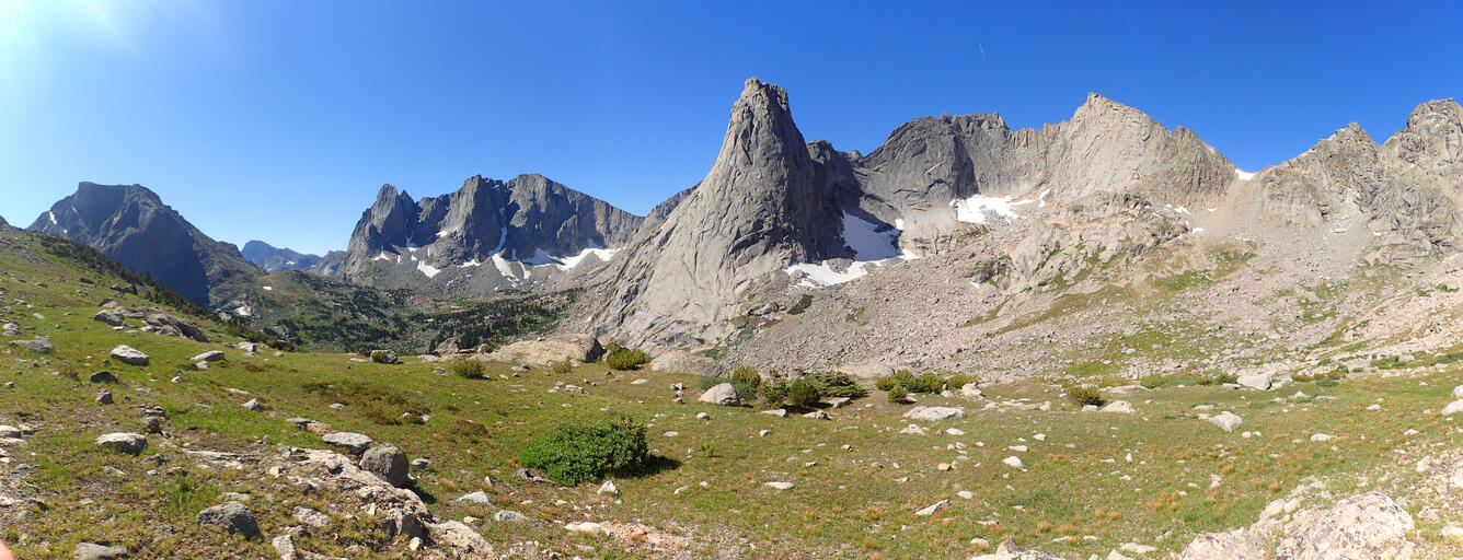
Not all mountains in the Yellowstone region are volcanic in origin. The Wind River Range, southeast of Yellowstone National Park, is an excellent example of an ancient pile of rocks that has been sculpted by more recent tectonic and glacial forces.
Yellowstone Caldera Chronicles is a weekly column written by scientists and collaborators of the Yellowstone Volcano Observatory. This week's contribution is from Stanley Mordensky, geologist with the U.S. Geological Survey.

The Greater Yellowstone Ecosystem (GYE), one of the largest nearly intact temperate-zone ecosystems remaining on Earth, is comprised of a volcanic plateau resulting from the Yellowstone hotspot, the Snake River Plain (which is partially a product of caldera-forming eruptions caused by the hotspot) to the southwest of the plateau, and several high mountain ranges along its other margins. When compared to the relative interest given to the surrounding ranges, the Yellowstone Caldera complex of the volcanic plateau receives an understandable degree of attention; however, the adjoining mountain ranges are no less important and have been around far longer than Yellowstone Caldera. For example, the volcanic rocks of the Absaroka Range are roughly 20 times older than the youngest Yellowstone caldera-forming eruption. Other mountain ranges in the region are not volcanic, but instead were lifted by tectonic forces.
The Wind River Range extends roughly 220 km (136 miles) from Dubois to South Pass City, WY, with a width of approximately 65 km (40 miles). The western Continental Divide runs along the crest of the range, with Gannett Peak (4,210 m or 13,810 ft) being the highest point not just in the Wind River Range but also in the State of Wyoming. The core of the range consists of gneiss (a metamorphic rock caused by intense heat and pressure) and igneous intrusions that have been influenced by metamorphic processes. These rocks range in age from 3.4 to 2.3 billion years. In other words, the majority of the rock that now composes the Wind River Range is older than half the age of the Earth and was once deeply buried beneath the Earth’s surface.

During portions of the Paleozoic (542 to 251 million years ago) and Mesozoic (251 to 65.5 million years ago) eras, the region was part of an inland sea, as evidenced by deposits of sandstone, mudstone, and limestone found along the foothills of the Wind River Range. These sequences of sedimentary rock are common throughout the GYE.
At some point, those rocks began to experience uplift, but the exact timing of that uplift has proven difficult to constrain precisely. Most geologists tend to agree that the Wind River Range experienced uplift between about 65 million years ago and about 50 million years ago, although there is some evidence that the uplift may have begun tens of millions of years earlier and lasted tens of millions of years longer. Erosional evidence suggests that the uplift did not occur as a single episode, but instead may have taken place in pulses. Over the duration of the cumulative deformation, uplift raised the rocks of the Wind River by about 14.5 km (9 miles) vertically, and laterally transported the rocks by about 25 km (16 miles). The faults that accommodated this displacement are located to the southwest of the Wind River Range. In historical time, these faults have remained aseismic.
Geoscientists call mountain-building events orogenies (with oros being a Greek term for mountain genesis). The orogenic period of the Wind River Range coincides with the formation of many mountain ranges forming the Rocky Mountains across western North America, and geologists refer to this period as the Laramide Orogeny (named after the Laramie Mountains of eastern Wyoming).
Geologists attribute the Laramide Orogeny to the subduction of an oceanic plate, specifically the Farallon Plate, beneath the North American Plate. This subduction began roughly 160 million years ago, but the Laramide Orogeny only commenced around 80 to 70 million years ago. While most subducted plates sink deep into the Earth relatively quickly after traveling less than a couple hundred kilometers beneath an overriding plate (behavior sometimes referred to as steep subduction), for some of its history the Farallon Plate traveled >1,000 kilometers (>600 miles) beneath North America at relatively shallow depths compared to what would be expected with steep subduction. Even today, parts of the Farallon Plate located beneath the Mississippi River are at shallower depths than oceanic crust subducted roughly only half as long ago. Geologists term this flat-slab subduction and are still researching exactly why it occurs, but a consequence is that the shallow subducting plate pushes crust and mantle material ahead of it, causing uplift, although the mechanics of this process are not well understood. The flat-slab subduction of the Farallon Plate may also explain the origin of the magmas that fed the Absaroka volcanoes along the northern and eastern borders of the Yellowstone region, as these magmas are more chemically characteristic of volcanoes near subduction zones (i.e., within a couple hundred kilometers of plate boundaries) than in the middle of continental plates.

The timing of the Laramide Orogeny varied geographically across western North America. Much like with its start, the end of the Laramide Orogeny has yet to be determined with confidence, but probably stopped around 55 to 35 million years ago. Well after the uplift of the Wind River Range ceased, glaciations like the Bull Lake (about 150,000 to 130,000 years ago) and Pinedale (22,000-14,000 years ago) events sculpted the mountains, creating the beautiful landscape we enjoy today.
References:
Axen, G. J., van Wijk, J. W. & Currie, C. A. (2018) Nature Geoscience https://doi.org/10.1038/s41561-018-0263-9
Blackstone (1993) The Wind River Range, Wyoming: An Overview. Wyoming Geological Association. Jubilee Anniversary Field Conference Guidebook: Wyoming Geology, Past, Present, and Future. Pg. 121-140.
Gutscher (2018) Scraped by flat-slab subduction. Nature Geoscience. 11. Pg. 890 -891. https://doi.org/10.1038/s41561-018-0270-x
Get Our News
These items are in the RSS feed format (Really Simple Syndication) based on categories such as topics, locations, and more. You can install an RSS reader browser extension, software, or use a third-party service to receive immediate news updates depending on the feed that you have added. If you click the feed links below, they may look strange because they are simply XML code. An RSS reader can easily read this code and push out a notification to you when something new is posted to our site.