
R/V Pelican Research Cruise with Dr. Julie Richey and Caitlin Reynolds from the Climate R&D Program
Dive into what it is like aboard a scientific research vessel in the Gulf of Mexico with Dr. Ariana Sutton-Grier. A very special thank you to Dr. Julie Richey and Caitlin Reynolds for their invitation to join their research trip and their assistance with this story.
Setting Sail

At the end of November 2022, I was invited to join a sediment trap recovery and redeployment cruise on the R/V Pelican in the Gulf of Mexico. A sediment trap is a moored instrument that can be deployed to collect sinking particles in the ocean. Why would scientists care about sinking particles in the ocean, you ask? The ocean is a critically important carbon reservoir. Marine life converts carbon dioxide from the atmosphere into biomass through something called the biological carbon pump. That biomass eventually sinks to the seafloor as particles, where it is stored (semi)permanently. Despite extensive research, directly observing the biological carbon pump is difficult, and the transport, transformation, and biological composition of ocean particles has been elusive and poorly understood. Sediment traps allow scientists to measure and study particle flux in the deep ocean throughout the year because they can be programmed to continuously collect samples at weekly intervals. This would be impossible to accomplish if scientists had to take a ship hundreds of miles offshore to sample manually. Studying these particles can help scientists better understand the biological carbon pump and the role it plays in modulating Earth’s climate through the drawdown of carbon dioxide.
I excitedly flew down to New Orleans where I met Dr. Julie Richey and Caitlin Reynolds, geologists at the USGS St. Petersburg Coastal and Marine Science Center in St. Petersburg, FL. From there, we drove down to LUMCON (the Louisiana University Marine Consortium), home port of the R/V Pelican.

We arrived mid-afternoon to load our equipment on the boat. It was my first time on a research vessel, and I was impressed by its size, 116 feet long. The R/V Pelican can hold up to about 14 science staff and holds an additional crew of 10 people. I brought my stuff to one of the science crew berths and then explored LUMCON briefly. We also got our safety briefing from Captain Tad.
After having dinner on shore, we set off at about 8pm. It was already dark so it was hard to see, but I could still make out some dolphins playing in the splashing waves at the bow of the boat as we headed out to sea. The plan was to make our way out to our sampling site overnight so we would be ready to begin work in the morning.
Collecting the Marine Sediment Traps
Just before 9am the next morning, we reached the set of coordinates where the sediment trap sampler had been deployed in the spring (28°13.392 N, 89°07.170 W in 1,150 meters of water). As I came out on deck, I could tell that stress levels were a bit high. This was because the scientists now had to locate the marine sediment trap, which was 1,150 meters down at the bottom of the ocean, within a few hundred meter radius of the coordinates recorded when it was deployed in May. The sediment traps are suspended in the water between an anchor on the ocean floor and buoys opposite the anchor pulling towards the surface. A small buoy (to make capturing the mooring out of the water easier) is attached at the very top to the first big buoy which is then attached to two sampling units and then a second large buoy at the end towards the anchor. Along that span are acoustic releases that when signaled, can release the samplers from the anchor and let the buoys carry them to the surface.

To release the sediment traps, we got out the dunking transducer (or “dunker” for short as the crew called it) and turned it on. The dunker is a small instrument that pings the acoustic releases at the bottom of the ocean. Once the dunker and the acoustic releases are communicating, the dunker can send a signal for the release of the sediment trap mooring from the bottom of the ocean.


I mentioned that the scientists were stressed and that is because there are two potential points of failure here. First, the dunker can have trouble talking with the acoustic releases on the bottom. This occurred at first until we realized there was another piece of acoustic equipment on the boat interfering with the signal. Once that equipment was turned off the dunker communicated just fine. The next point of failure is that the release can fail on the bottom of the ocean. So, we sent the signal to release and then held our breath waiting to see if it worked.
After several tense minutes there was a shout and then lots of excitement as someone located the large buoys floating near the boat. After that everyone could relax because it was now “simply” a matter of getting the samples out of the water and then redeploying the sediment traps to the bottom of the ocean. It was a multi-hour process that involved many people (scientists and the crew members) and lots of the boat’s special equipment, but once the samples surfaced, we knew we were going to be able to retrieve them, and the relief was palpable.


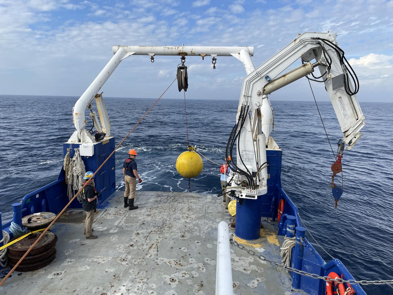

Each step of bringing up the equipment from the ocean required teamwork, communication, patience, and hard work. To retrieve the samples, the captain maneuvered the boat closer to the floating buoys. The smaller buoy was caught with a hook and then pulled up onto the boat, followed by one of the large buoys, the samplers, and then final large buoy. Once each piece was brought in from the ocean, it had to be secured on deck so that the buoys and sediment traps would not roll around on the deck of the boat.
Collecting the Samples and Redeploying the Sediment Traps

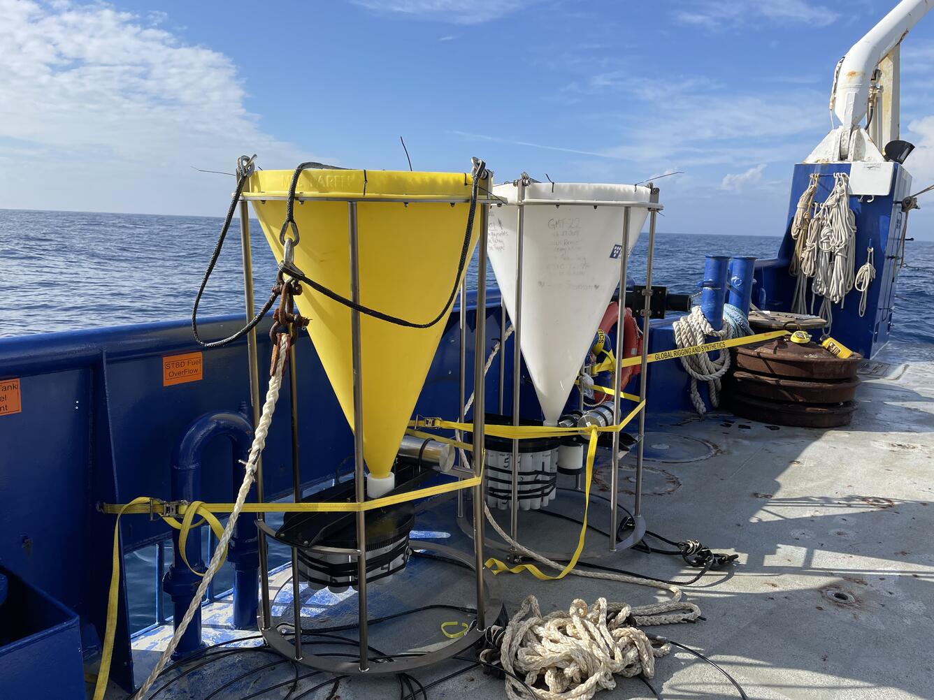
Once all the sampling equipment was on deck, the work began of unloading the sample bottles. Each bottle had been open for either 1 week or 2 weeks during the interval from May to November 2022. The length of time it was open, collecting every particle sinking through that 1-meter diameter patch of ocean, depended on whether it was during the more productive season (July to August) or not. During these productive windows of time, the sediment trap bottle is often set to only be open 1 week because if it is open longer, it can collect so much sample material that it overflows and blocks the sampler from closing which then ruins the rest of the sample collection.
Next all the sample bottles were removed, and each bottle’s pH was measured to ensure that the seawater solution did not become too acidic for sample preservation. New batteries were installed in both the sediment trap equipment and the acoustic releases (this is one of the most important steps to ensure that the traps can function for another six months until collected again). The whole mooring was rinsed well with sea water. Then new bottles filled with a formalin solution (a preservative seawater solution that prevents degradation of sample while it sits in the deep sea) were attached so that the sampler could be deployed for another 6 months until May 2023.


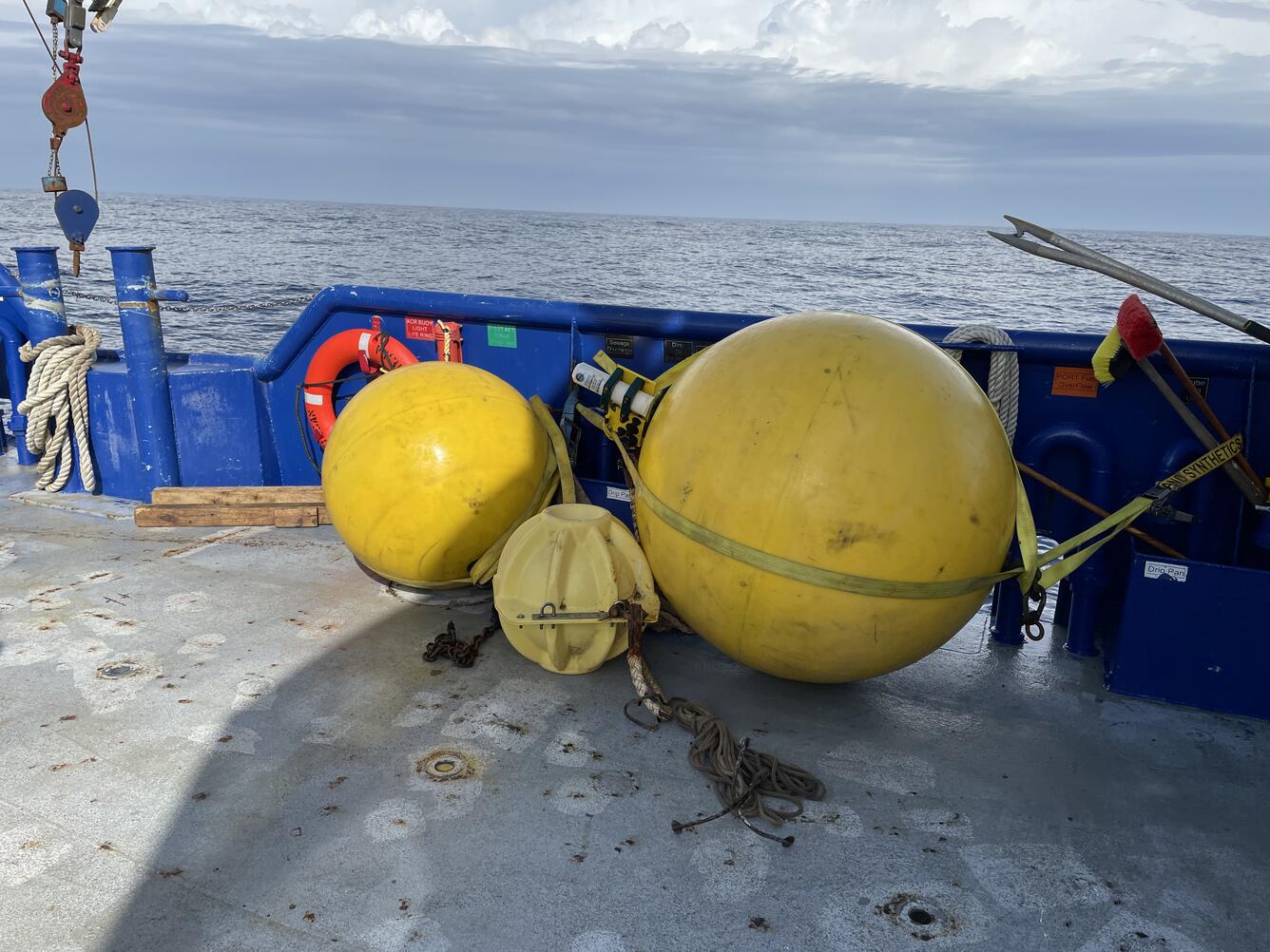
Once we were ready to deploy again in the early afternoon, the process went in reverse dropping the pieces of the mooring into the ocean with the little buoy attached to the big buoy, then the 1st sediment trap, then the 2nd sediment trap, then the acoustic releases. The last thing to be dropped was a big anchor made up of a stack of 3 repurposed old railroad wheels. The coordinates where this anchor dropped were recorded, so the scientists can return to that precise location to recover the sediment traps again in summer 2023. The mooring was successfully redeployed by ~2:20pm and is now collecting samples throughout the next 6 months.
Collecting Conductivity, Temperature, and Depth Data
The next step was to deploy the Conductivity, Temperature, and Depth (CTD) sensor. It is mounted on an apparatus called a rosette, which is equipped with 12 large (20 liter) bottles to sample water from different depths between the surface and 1000 meters. It resurfaced after about 40 mins. All was good except one water bottle misfired and didn’t collect a sample from 500 meters. So, we had to send the CTD down one more time to re-collect samples at that depth. We measured pH and took samples to analyze the water chemistry back in the lab.


Collecting Foraminifera

Once the CTD came up, the last step was to collect some live foraminifera using a plankton net. The Richey lab is working to cultivate select species of these single-celled living fossils in the lab to learn more about how to interpret the climate and environmental information recorded in their shells. They use the shells of foraminifera preserved in marine sediments to reconstruct ocean conditions in the geologic past, and modern ecological studies provide insights into the habitat preferences and food sources of these organisms. They have recently found that a group of these foraminifera classified as “non-spinose” have a chemical signature very different from the surrounding seawater. They hypothesized that these foraminifera are living within a microenvironment of marine snow, or decaying particles that fall to the ocean floor. This discovery is changing the way we interpret signals recorded in fossil foraminiferal shells. Instead of telling us directly about seawater chemistry, they may be telling us about ocean food chain dynamics and biological productivity in the past ocean.
The scientists used a plankton net sent down to 100 meters depth to catch the foraminifera living in the surface ocean and then identified them under the microscope. They successfully collected 10 Globigerinoides menardii specimens and gave them fun names (with musician themes on this trip) to help keep them all straight. The scientists placed each foram in its own flask, like a miniature aquarium, and fed them some “snow” on the boat which helped the researchers ensure that they were still alive and healthy. The microscope work was hard for everyone because of the rocking of the boat, but they managed to collect the species they were looking for.
Heading Home
The boat turned around in the evening after dinner and headed for shore. We motored all night through some very rough seas (I was told this was some of the roughest seas the researchers had experienced in the Gulf), but we arrived back to the dock by about 9am the next morning. At that point it was time to get the samples labeled for mail pick-up and all the equipment either stored away or ready to get shipped as well. Once the clean-up was complete, we headed back toward New Orleans for everyone to catch their flights home. It was a whirlwind sampling trip but what an exciting opportunity for me to get to observe the sampling process and help a little with the sample processing on board the boat. Despite the rough seas, I really enjoyed taking my first ever research cruise and look forward to future field excursions and opportunities to learn more about the work our scientists are doing first-hand.
Get Our News
These items are in the RSS feed format (Really Simple Syndication) based on categories such as topics, locations, and more. You can install and RSS reader browser extension, software, or use a third-party service to receive immediate news updates depending on the feed that you have added. If you click the feed links below, they may look strange because they are simply XML code. An RSS reader can easily read this code and push out a notification to you when something new is posted to our site.